When it comes to the use of geosynthetics for stabilization, reinforcement, or even the capping of a landfill, the real test of their effectiveness is their ability to mitigate the issue that served as a driving factor necessitating their installation in the first place.
Case in point: the use of Presto Geosystems’ Geoweb for a Florida road drainage project, which created vegetated channels to shore up an embankment.
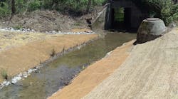
Six years after its 2012 installation, flooding problems on the road have been eliminated and the channel system is performing as intended, providing the desired natural vegetation while protecting the channel side slopes from erosion that previously limited stormwater volume and contributed to flooding.
“The erosion prevention material is in place and has not collapsed. It’s durable. We’ve had two storms since we installed it and it has performed,” notes Carolina Alvarez, the project manager, an engineer for project owner Brevard County, FL.
Lake Drive in Cocoa West, FL, had been experiencing chronic drainage issues leading to flooding. The Bussen-Mayer Engineering Group consulted with stormwater and erosion control specialists R.H. Moore and Associates for ideas to mitigate the challenges with a newly planned channel on behalf of Brevard County.
The channel design included box culverts as well as some open areas to enable more volume to help alleviate flooding potential.
The options considered included gabions, articulated concrete block mats, fabric-formed concrete, and Presto’s Geoweb tiered channel system.
Geoweb was chosen to meet the project’s dual requirements of erosion protection and a natural appearance. Geoweb tiered channels are designed to offer flexibility and adaptability to varying infill types, landscape contours, curves, and obstructions. It accommodates select vegetation or aggregate or concrete for hard-armor protection where required.
The chronic drainage issues along the Florida roadway were alleviated by incorporating naturally vegetated channels to prevent erosion to allow for higher stormwater volume and to eliminate potential for flooding.
The Geoweb channel system consisted of Mirafi 2XT reinforcing geogrid and 15,000 square feet of Geoweb green-fascia wall panels.
Multilayered Geoweb channels can be designed with steep banks and small horizontal footprints to allow for flood storage. The channels are designed to withstand high flows for short durations while allowing natural vegetation in contrast to the use of hard armoring solutions such as gabions or concrete.
The flexible design allows Geoweb channels to tolerate reasonable differential settlement without loss of integrity for the goal of high performance even in soft-soil environments. Concrete or grout infill in the outer cells may be used when heavier flows are expected for greater resistance to shear stresses.
The installation was completed in six months by Masci Corporation.
“It’s a plastic material and it comes woven together in pieces in a terrace fashion,” notes Alvarez. “You fill each of the little openings with stone mixed with soils. The installation is a little tedious, but if you have the right crew to do it, it’s not any more tedious than installing gabions, for instance, which was another of the options we looked at, but the cost was prohibitive.”
Cost can be a major factor when public entities have to mitigate flooding issues. Brevard County was able to finance the project through a grant and funding from its stormwater utility.
“We needed to make sure we didn’t go over our budget,” says Alvarez. “That’s why we decided to leave it as an open channel, but also there’s a very nice subdivision right behind it and those folks look at it every day. We also didn’t want it to look ugly.”
The subdivision residents would have preferred the county install box culverts in that portion of the project, “but box culverts are very expensive,” notes Alvarez.
The county chose the Geoweb as what arose as the best solution at the time, although it had never been used in the county before, she says. “We didn’t know anything about it, so it was also a good way of testing other options that are out there for the future.”
With the vegetation now grown in, it looks like a ditch, county officials say.
Alvarez notes that the solution requires a different approach to maintenance. “You have to weed it—you can’t mow it because you would break the material,” she says.
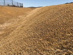
Drainage channels around the landfill at Nellis Air Force Base
Ultimately, county officials are pleased with its performance.
“It has alleviated a lot of the flooding,” says Alvarez. “We’re happy about it. We’re looking for additional FEMA funding to complete additional projects, but because there have been so many storms, the funding is minimal and the applicants are many.”
The Lake Drive project is one of 13 projects listed on the West Cocoa Basin Study.
“We have not completed all of the projects because of the cost,” says Alvarez. While this project has alleviated flooding on the Lake Drive area, “upstream from it, there are a couple of subdivisions that still have flooding issues, and until we complete all of them, we’re not going to be able to relieve those and it’s not going to be a complete 100% solution.”
Because the groundwater is high in the region, it is difficult to prevent flooding completely; success in alleviating flooding also depends on the size of the storm, Alvarez points out.
Cortez mine in Nevada
Having a county stormwater utility has provided the basis for being able to move the needle forward, says Alvarez.
“When we started the utility, there was an ordinance that was approved, and unless a supermajority changes that, we are only to get grants and utilize money from the utility,” she says. “It makes it a little bit difficult because the projects are in the millions and we don’t collect as much, so we have increased the fee since its inception. It has doubled now, but it’s still not enough.”
Separate projects in the area are focusing on Indian River Lagoon water quality and are being funded by the passage of a half-penny sales tax.
Alvarez points out that public sector projects often receive support when the messaging helps constituents to understand the need for them. In Brevard County, input from residents, political entities, nonprofit groups, and academic institutions have helped to get the message out there.
“No one wants a flood, and no one likes to see a rotten lagoon,” says Alvarez. “It took a lot of billboards, public service announcements, and meetings with the public to make them understand.”
Sitting on a Gold Mine
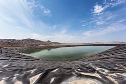
Situated in the Crescent Valley between the Cortez and Shoshone Mountains, the Cortez Mine is in an area that has been mined since 1862. Surface water is scarce in the mine and in the surrounding region in northern Nevada, necessitating sustainable water solutions during mining operations.
In 1969, the US Bureau of Mines constructed a pilot plant that made heap leaching of gold viable. Around 1971, low-grade ore from the Gold Acres deposit at Cortez was heap leached, and the mine shifted to a gold operation.
Multiple feed deposits have kept the mine going, including the Horse Canyon, Pipeline, Foothills, and most recently, Gold Rush deposits.
In the 1980s, a pond for water storage was built out of a flexible material, very low-density polyethylene, or VLDPE. Although the material was designed with optimal elongation and weldability properties, it provided limited resistance to ultraviolet light, resulting in its rapid breakdown when exposed to sunlight.
The VLDPE liner was removed and replaced with high-density polyethylene (HDPE), but that material also broke down, resulting in leakage through the double liner. Harsh weather, steep slopes, and overall mining operations overwhelmed the containment system, necessitating a design that could accommodate significant drainage.
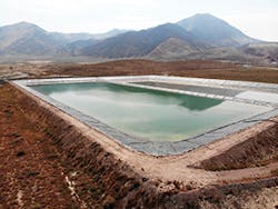
To mitigate the issues with the Barrick Cortez Water Storage Reservoir, mine owner Barrick Gold brought in Newfield Engineers. The company designed a new 625,000-square-foot double-lined pond using Agru America’s 60-mil single-sided HDPE MicroSpike liner with a 200-mil Agru Geonet as the separator between liners to enable quick flow to the leak detection sump to help crews pinpoint and seal leaks faster.
Agru MicroSpike, designed as a highly durable geomembrane liner with consistent friction angle values, was used to address slope stability. The engineering team used thermal fusion welding to create an impermeable seal between adjacent sheets.
The installation was performed by Sierra Geosynthetic Systems in 2017 and to date has resulted in a leak-free pond.
Revegetated channel
Nellis Air Force Base
Nellis Air Force Base in southern Nevada is considered one of the most advanced combat aviation training facilities in the world, with multiple military schools and more squadrons than any other US Air Force base.
It is home to every type of aircraft in the Air Force. Its military population numbers more than 40,000.
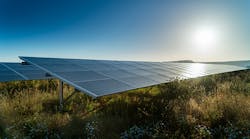
Nellis Air Force Base also hosts one of the largest solar photovoltaic arrays, supplying more than 25% of the power used at the base.
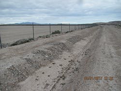
Engineers from Ahtna Engineering Services, an Alaska Native Regional Corporation design/build firm that has performed hundreds of federal construction projects, were challenged with erosion issues in the perimeter channels surrounding one of the closed landfills at the base—particularly significant erosion on the channel side slopes.
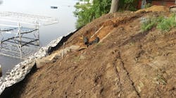
Previously designed with natural compacted subgrade and riprap at the bends, the side slopes of the channel had eroded, causing sediment issues and ultimately side slope failure of the channel in places.
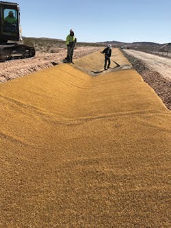
Watershed Geo’s HydroTurf Z was used as a cost-effective, low-maintenance, long-term revetment solution for perimeter channels around the closed landfill.
HydroTurf is an engineered revetment solution designed to provide armoring of hydraulic structures against high velocity and shear stress with the appearance of natural vegetation. HydroTurf Z is used in less critical applications involving lower velocities and flow conditions.
Sommer Carter, Ahtna senior environmental engineer, notes, “The primary purpose of using engineered turf is to provide a long-term solution to minimize erosion in the earthen drainage channel at the closed landfill located at Nellis Air Force Base. Using a material that requires minimal maintenance and has a high level of durability is important, as traditional methods were not feasible in the tough terrain of the Nevada desert.”
Some 60,000 square feet of the HydroTurf product were installed in 2018 in a tan color to blend in with the natural environment. The installation was done in under a week with lightweight equipment.
Once the engineered turf was installed, HydroBinder cementitious infill was raked into the fibers for even distribution. HydroBinder is hydrated and left to cure and harden into permanent protection for the channel.
