Leslie Nemo is a freelance science writer based in the U.S. Nemo can be reached at [email protected].
undefinedDecades of work have gone into improving wildlife habitat in the Chesapeake Bay. Integral to the goal is a problem coastlines around the world have run into: How to preserve wetlands.
Specifically, the Chesapeake Bay Program, an organization that’s been working with the region since the 1980s, wants to restore or recreate 85,000 acres of wetland and improve another 150,000 acres by 2025. So far, the CBP has conserved about 10,000 acres.
“It's hard to accomplish a wetland gain goal when at the same time, you're losing a lot of wetland,” said Pam Mason, a senior research scientist at the Virginia Institute of Marine Science.
That’s why the CBP is at the beginning of a plan to chart the future of each meandering stretch of bay.
Understanding Wetlands
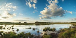
Wetlands — the swamps, bogs and marshes where water and land mix — do more than support coastal wildlife. The habitats also break storm waves and reduce the amount of energy brought ashore, all while keeping flooding levels lower. And when storm waters flow over land, the wetlands filter out some contaminants.
Climate change and other human actions, however, are erasing wetlands and the benefits they come with. Hurricanes, which scientists expect climate change to make more severe, flood wetlands with ocean water storm surges that kill plants with too-salty conditions. Meanwhile, rising sea levels, which are advancing between three and almost five millimeters a year in the Chesapeake, inundate the plants with water and drown them in place, said Elliott White Jr., a coastal wetlands researcher at the University of Virginia.
Wetlands can save themselves if the plants trap sediment and retreat towards land. But human infrastructure interferes: Parking lots and other construction prevents wetland flora from taking root.
“As sea levels rise, the systems which have the ability to kind of move backwards and keep pace, now they're hitting this wall that they're unable to get around,” White said.
Per CBP estimates, rising water levels, encroaching development and more eliminated over 1,500 acres of wetland between 1992 and 2010, bringing the region down to about 282,000 acres total. To see what preservation or rebuilding actions need to happen, The CBP started a year-and-a-half long project in May to see how modeling the future wetlands might work. Calculations that synthesize information about the current status of a shoreline can try to predict how much of it will be around (and where) in the coming years.
Finding the Right Model
What kind of model fits well for one nook in the Chesapeake might not work elsewhere. Covering lots of ground with one calculation might mean substituting hyperlocal information with averages, which can distort the reality of what could happen in some areas, White said. Each model also demands different resources. One might require a level of detail that is not available for every mile of Chesapeake coastline, for example, Mason said. More precise and higher-resolution models also take more time and are more expensive.
Researchers with the CBP are comparing modeling options before the organization runs trials with real data for two stretches of the bay. Mason suspects that the locations will represent the range of landscapes throughout the Chesapeake — one might be more rural while the other is urban, and coastline from Maryland and Virginia will appear.
Once completed, Mason hopes the models will help the CBP and other organizations specify wetland conservation locations. Local, state and federal governments could tap into the models to see where they should create wetland preservation programs or launch campaigns to encourage others to convert their properties.
Promotional messaging could be a big part of the CBP restoration goals, as Mason suspects current coastal use and values could be one of the largest barriers to expanding wetlands. Some local government revenue relies on property taxes, with the most lucrative lots being waterfront homes owned by people who typically tap into public services the least, Mason said. Buying properties to turn into marsh means municipalities forfeit the income, and many residents want lawns — not marshy expanses. Waterfronts also host aquaculture, shipping, defense and other businesses that rely on docks and cement walls for boats. Expanding wetlands would have to extend or move infrastructure, changes businesses might resist.
As organizations take conservation action based on wetland models, White said it is important that teams consult researchers who know how to interpret the calculations.
“There can be a lot of confusion and a lot of misunderstanding by people who are not modelers who don't have that experience,” he said.
The state of Virginia offers a few models that do not agree perfectly on outcomes, for example, or the information each provides can look the same though it is not, which can make planning challenging. Modeling the future of Chesapeake wetlands is the first step in a larger scheme to expand their footprint — a struggle Mason can identify clearly.
“There's going to be this obvious tension between developed lands, like people's yards, and [navigation] channels and businesses and wetland movements,” she said.
And though the coming conflict has been on the CBP radar for a long time, the negotiations for the sake of the wetlands are just beginning.
Resources:
• https://www.nature.com/articles/ngeo2251?proof=t
• https://link.springer.com/article/10.1672/07-232.1
• https://bit.ly/EPAWetlandsStormwater


