Zachary H. Ranstead is project manager with T&M Associates. Ranstead can be reached at [email protected].
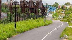
In Phoenixville Borough, Pennsylvania, 20 miles northwest of Philadelphia, the former Phoenix Iron Works foundry lies alongside the waterway of French Creek. A manufacturing site since the 1700s, the foundry was closed in the 1980s and demolished in the 1990s. As the borough and surrounding communities experienced an economic rebirth in recent decades, the 64-acre industrial parcel sat derelict.
A number of redevelopment projects were proposed for the site, but until recently all had been discarded. Almost the entire site lies along the Federal Emergency Management Agency’s (FEMA) floodplain, a geographic area the agency has defined according to varying levels of flood risk. In addition, the borough adopted even more stringent floodplain requirements. Any development would have to meet a zero-increase standard, meaning it could not result in any measurable increases on flood heights, making most projects unviable.
It took a rigorous and more accurate reassessment of outdated FEMA models to determine what project could meet the strict floodplain standards. Once those standards were met, the resulting project site under construction was built robustly enough to weather the effects of the recent Hurricane Ida without any flood damage.
Reassessing FEMA’s Analysis
The latest redevelopment proposal is a mixed residential project with townhomes, condominiums, additional borough parking and a new fire station. It was approved and is currently under construction following the aforementioned reassessment of FEMA’s floodplain model for the site and surrounding area.
A review of the French Creek models produced by FEMA indicated that the original floodplain analysis was prepared in 1977. Aside from a datum shift, no further updates had been made to the FEMA result since the original analysis. At the time of the original study the existing steel mill buildings were present and represented a large floodplain obstruction on the site. A dam depicted in the original FEMA profile was found to be 8 feet lower in the present condition.
The outdated FEMA model also factored in two bridges leading into the site area and one just downstream. The downstream bridge had been reconstructed in 1991, whereas the FEMA study was based on a more obstructive stone arch bridge originally constructed in 1847. An old rail bridge leading into the site was partly collapsed and hazardous, and its complete removal would be required for any project. The second dilapidated bridge on Paradise Street would also be initially removed and eventually be rebuilt for site access and traffic circulation. All these factors would be considered as FEMA’s models were subjected to reassessment and remodeling.
A 5,000-foot stream length floodplain model was developed which included the present condition of these noted features to create an updated and highly detailed baseline of existing conditions. In its original study, FEMA had seven analysis sections. The updated model, using HEC-RAS software, was far more robust, with 80 analysis sections.
The removal of both bridges resulted in a development model with a flood elevation that would comply with both Borough and FEMA floodplain requirements. With this proof-of-concept favorably received by the borough, work could finally begin. The anticipated completion of the project will be sometime in late 2022.
Storm Water & Erosion Control During the Construction Process
A loop road which paralleled the French Creek stream was constructed and purposely caused the development site to assume a bowl-like shape for erosion control purposes. Permanent storm water outfalls were simultaneously installed with backflow prevention measures. This separated the development area from the floodplain and allowed runoff during construction to be captured and treated with sediment traps and basins prior to discharge.
A new Paradise Street bridge was required for additional site access and circulation. The bridge’s deck would be set more than 6 feet above the old bridge and its length widened by 40 feet. This design element would allow floodwater to pass underneath it, greatly reducing the level of these waters and keeping the development well within floodplain requirements.
The new bridge includes a steel truss superstructure, a nod to the site’s ironworks heritage, and a protected pedestrian sidewalk which connects the development to nearby baseball fields.
Post Construction Storm Water Management Design
The existing site condition was nearly entirely impervious, meaning it would allow little or no storm water infiltration and contributed to increased levels of storm water runoff and flooding. Storm water infiltration was not recommended because of the potential pollutants associated with a derelict industrial site.
To address the storm water rate and volume mitigation requirements, the post construction design of the development would “green” the site with lawns, open spaces and other areas where soil and vegetation could be established. The soil fill cap addressed environmental concerns and raised the new homes above the flood elevation. New driveways and roadways would also guide runoff before discharge into the storm sewer systems.
Storm water outfalls are distributed along the stream length to avoid concentrating flows. Underground detention best management practices (BMPs) are provided to capture a “first flush” event, enable slow discharge and ensure water quality included surface vegetated rain gardens and hydrodynamic devices. Through these measures, elements such as hydrocarbon, debris and silt can be managed through the storm water discharge process.
Hurricane Ida & Model Validation
Hurricane Ida devastated the region, with rainfall levels that overwhelmed storm water systems in many communities. This resulted in catastrophic flooding that put municipalities and major roadways underwater, as well as the deaths of dozens of people across several states.
The French Creek watershed was impacted similarly from the remnants of Ida as excessive rainfall hit the area on September 1 of this year. By this point, the site was still under construction, but the proposed floodplain elements of the project were effectively complete. The site has been filled, the old rail bridge removed, and the Paradise Street bridge reconstructed at the point of higher elevation as planned.
The model for the French Creek redevelopment project was validated when a site inspection after peak water receded showed the site remained high, dry and unimpacted by one of the worst storms in recent U.S. history. The floodplain and storm water design elements had worked exactly as planned for this event.
Conclusion
The reassessment of the FEMA modeling for the site, while rigorous, was done cost effectively and in increments, at first using publicly available data and basic field measurements. It illustrates the importance of working with design and engineering firms, such as T&M Associates. FEMA models should always be reviewed in the context of present conditions for land development projects, as they may be obsolete.
Once the models had been properly reassessed and updated, with improvements and additional topographic detail, the current French Creek redevelopment project became viable. Good planning allowed for a remediation of a historic industrial site and the creation of a project that will bring lasting benefits to the local community.
Validation of FEMA’s product, outdated due to modeling improvements and topographic changes, yielded a viable redevelopment project, which also remediated the former industrial use.