On a fall day in 2018, something changed in the waters of the Cache la Poudre River and more than 10,000 fish were killed as a result. The grisly scene along a section of the river that flows through Fort Collins, CO, shocked city residents and staff and prompted an investigation by Colorado Parks and Wildlife.
A year later, the agency concluded its efforts without finding a definitive cause, in part because there simply wasn’t enough water quality data available to understand what was happening in the river before, during, and immediately after the event.
While Fort Collins and other entities monitor the river’s water from its headwaters in the Rockies to its eastern reaches, efforts have typically been limited to the intermittent collection of samples delivered to a lab for analysis. That, however, is no longer the case.
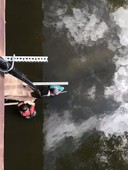
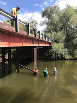
Due in part to the catastrophic fish kill and in part to a bit of serendipity, the city has partnered with Colorado State University (CSU) and In-Situ Inc. to install eight permanent water monitoring stations along the river to continuously monitor multiple water quality parameters.
Specifically, this unique partnership brings together the stormwater and water quality divisions within the city’s Utilities department, CSU’s Warner College of Natural Resources, and In-Situ, an environmental monitoring equipment manufacturer headquartered in Fort Collins.
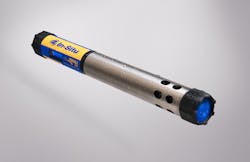
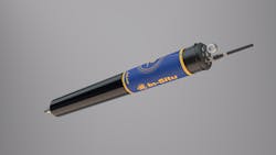
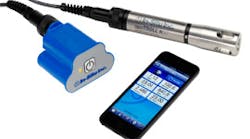
At each monitoring station, an In-Situ Aqua TROLL 500 or Aqua TROLL 600 Multiparameter Sonde will collect data on temperature, turbidity, depth, pH/ORP, dissolved oxygen and conductivity. A telemetry unit in each installation relays data to HydroVu, In-Situ’s cloud-based data services platform, for analysis.
A Collaboration Founded in Common Interests
The partnership originated with a series of conversations: Basil Hamdan, the city’s stormwater quality engineer, met Matt Ross, a CSU professor, at a conference and the two discussed how they might work together to collect more data from the river. Separately, In-Situ’s Application Development Manager Eric Robinson met both Hamdan and Ross and discussed with each of them ways that the company might help them reach their monitoring goals.
“The city had the need, CSU had the capability and a shared interest, and we had the expertise to help make it happen,” says Robinson. The fact that all parties were local and the need was acute helped the project come together quickly.
“It made sense to work with CSU to buy the equipment we needed and share it because we were both interested in the data,” adds Hamdan. “And having access to quality equipment and technical expertise from a local manufacturer has been great.”
While both the city and CSU have direct access to live-streaming data coming from the installations, CSU will process and manage the raw data and share it with the city. Since joining the University’s Department of Ecosystem Science and Sustainability last year, Assistant Professor Ross has had a keen interest in developing a research program around the Cache la Poudre River. He describes it as a classic western river, faced with the familiar challenges of fire, agricultural diversions, urban impacts, and drought. He says long-term sensor deployments in the river will produce high-quality data useful for trend analysis, immediate decision support, and as an educational tool.
“I’m interested in looking at impacts over time,” says Ross, “Frequency of low-flow years and anoxic events within those years, how turbidity is changing and where those changes are happening, but also building a decision-support system that can inform action that day or that week and help the city get out in front of water quality impacts.”
Hamdan adds that the monitoring data will also provide a baseline, should the Northern Integrated Supply Project (NISP) be approved. The proposed water storage and distribution project, which includes the construction of two reservoirs north of Fort Collins, will divert water from the Cache la Poudre River and potentially affect water quality.
In-Situ assisted with the installations, working side-by-side with students and city staff and providing technical assistance along the way. The first monitoring stations were in place within a matter of days, affirming for Robinson the efficacy of the partnership.
“We’re committed to helping agencies and municipalities get access to high-quality data, so that they can be proactive in understanding and protecting water quality in their communities,” says Robinson. “So far, this partnership has worked extremely well and could serve as a model for other areas that are too small to warrant a sustained, USGS monitoring program, but have water resources critical to their environmental and economic health.”
Taking a Deeper Dive with NGWOS
In fact, it’s unusual for a river such as the Cache la Poudre to be so scrupulously monitored. The US Geographical Survey (USGS) maintains real-time continuous monitoring networks nationwide consisting of more than 8,200 streamflow-gauging stations, 2,100 water-quality stations, 1,700 groundwater-level monitoring stations, and 1,000 precipitation stations. Yet the current National Streamflow Network covers less than 1% of the country’s streams and rivers.
To improve coverage and provide more useful data, the USGS plans to develop intensive monitoring networks in a small number of medium-sized watersheds (10,000–20,000 square miles) and underlying aquifers that are representative of larger regions. The Next Generation Water Observing System (NGWOS), as it is known, will use collected data to fill in data and knowledge gaps in regional and national water assessments and predictions.
Among the first of these intensive monitoring networks is the Delaware River Basin Pilot, where the USGS will install 50 or more In-Situ Aqua TROLL 500s as part of a pilot project to provide real-time data long term. According to the agency, these locations “will provide a platform for rigorous, transparent, and reproducible testing of emerging and innovative monitoring technologies.”
“We look forward to working with the USGS on this exciting project,” says Robinson. “It’s gratifying to be selected based on the accuracy and versatility of our equipment and our support.”
Adding Next Generation Telemetry
Coming soon to the Cache la Poudre River installations will be In-Situ’s new telemetry product, VuLink. Several years ago, the company identified the need for a data logger and telemetry device that would actually encourage remote monitoring and made the investment in research and development efforts necessary to produce a device that was easy to use and would reliably transmit data from anywhere in the world for a reasonable cost. The result is VuLink, a cellular and satellite telemetry device designed to fit and mount in a 2-inch (50-millimeter) tube or well for simple, secure, and reliable data transmission.
To make it easier to connect to a preferred or local cellular network, VuLink supports all networks that support 4G LTE Category M1/NB-IoT, including Verizon and other traditional CDMA networks.
Category M1/NB-IoT will provide the foundation of Internet of Things (IoT) for the next 10 years or more. It increases range for expanded coverage, and, with better signal penetration, many low-signal areas will now be suitable sites for deployment. VuLink also supports 2G for the EU, South Africa and other 2G-centric areas.
Because Category M1 and NB-IoT networks offer massive power savings for devices, VuLink can deliver two-to-six times the battery life of similar devices. At faster reporting rates, VuLink offers more than two years of battery life at 15-minute reporting intervals. Both widely available alkaline batteries and lithium batteries are supported, so battery type can be matched to a particular use case and ambient temperature.
For areas where cellular coverage isn’t available or its use isn’t permitted, an Iridium satellite version of VuLink gives global coverage regardless of location. And despite the higher power consumption of Iridium SBD data, VuLink battery replacement cycles exceed minimum instrument maintenance cycles.
Both Ross and Hamdan see public engagement as an essential part of the project. “My lab is not only focused on research and building processes to give the city clean data but also on making that data more accessible through visualizations and videos,” says Ross. “We want people to be able to see it and understand it.”
For communities that might want to replicate the partnership, Robinson suggests that three components must be present: a city culture that welcomes collaboration with other entities; academic professionals who have a clear vision of what they wish to accomplish; and a technical partner like In-Situ that is nimble enough to provide on-the-ground technical support.
“Remote monitoring is key to understanding what happened in the water before, during or after an event,” says Robinson. “It’s like filming something as opposed to taking a picture of it. And communities able to protect their rivers and watersheds in that way are better positioned for the long term.”
