At any given time, in any municipality, our underground infrastructure systems are keeping inspection teams busy. There is never a moment’s rest for the workers whose job it is to track down, inspect, clean, and repair these miles of stormwater pipe, outfalls, and catch basins. It’s almost as if Mother Nature has a running joke to prove her superior powers over our tireless efforts to “conquer and contain.”
Nonetheless, the figures are staggering regarding the amount of water lost every year due to failing systems. Contamination from combined sewer overflows (CSOs) and flooding add to the never-ending list of repairs that relentlessly drain the town coffers. However, with new equipment and a strict adherence to inspections, cities can operate in a preventive rather than reactive mode, and many are investing in this approach.
One organization, the American Society of Civil Engineers (ASCE), has been advocating a series of efforts that increasingly help municipalities understand how stormwater vigilance pays off. Rebecca Shelton wears two hats—she is the deputy director for the Department of Water Resources at the Gwinnett County Government in Georgia and also serves on the Report Card Committee for ASCE; she speaks with firsthand experience of the issues.
“As an organization, our members are all coping with the vast scenario of stormwater management that today is so much more on the front burner than in the past,” she says. “The ASCE members who specialize in stormwater management are the ones who have to come up with the policy statements, and they develop our report cards that highlight the infrastructure issues. Then, those findings from the report card are shared with the legislature and the public in their respective regions.”
Shelton says the report cards are the result of “a volunteer effort that includes the local agencies and municipalities across each state.”
“At ASCE, we have a Report Card Committee that collaborates to compile grading criteria, which is used by engineers and stormwater managers at the local level to assess what exactly is the ‘health’ of their respective infrastructure. All along we have been emphasizing that it is essential to know what’s going on before you have an incident, not afterward,” says Shelton.
She says the report card indicates how a locality performs across several measures. These include routine inspections that should be performed, including dam inspections, assessing the age of stormwater pipes and outfalls, and various stormwater management criteria whose status should be measured.
“Our belief is this is all about asset management and maintenance. In some urban areas where there may be more resources and staff, they can do a great job, but in rural areas where it’s all lumped into ‘drainage,’ less attention is paid to these efforts—until there is a sinkhole and the road falls in,” she notes.
The purpose of the reporting system “is to look at systems and see what are the short- and long-term needs, where is the municipality doing well, and where are improvements needed,” she says.
Once a local committee forms its report card and submits it, the community receives a grade based on input from the ASCE.
“This is the evidence they need to take to their legislature for funding to support staff, construction, and improvements,” says Shelton. “The states that invest in infrastructure have a direct relationship with economic growth of their area. Investors and industry looking at new locations want to know that transportation, roads, schools, and the overall infrastructure are in good shape. It only makes good economic sense to invest in these arenas, particularly water-related, as media headlines of flooding basements, polluted water supplies, and failing systems will clearly act as a deterrent for potential new growth.
“In Georgia, for example, we had a problem with dam safety as we only had four inspectors for the whole state to examine 4,000 dams. It’s an impossible challenge, and 200 dams per inspector is customary, not a thousand. Plus, this is not something you can conduct in a cursory manner, as public safety is at risk. Now, after our report card results were tallied, the legislature approved more staff, giving us 10 inspectors. So this is the kind of positive outcome the report cards can generate.”
She adds that the next time ASCE issues a Report Card, it will include a specific stormwater-related section, because “this so often falls under wastewater, but it should have its own specific merit measurements.”
Shelton adds that the overall grade for America on the currently pooled stormwater and wastewater measures is a D+, which, again, “is attributed to many places that have not made stormwater a priority,” she says.
“It’s a difficult call for competing resources. You have municipalities needing funds for police, fire, parks and rec—and then there’s stormwater. It doesn’t come to the top of the pile, but when you have a disaster, people want to know why there wasn’t money to prevent it from happening. If you pop every manhole and catch basin, if you use video inspection and find out where problems exist, you can go a long way to prevent these events.”

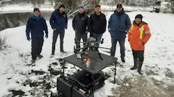
Geophysical Survey Systems’ UtilityScan
GPR unit
Mapping What’s Below
Evolving from a geological surveyor to a manufacturer of ground-penetrating radar (GPR) equipment to do the surveys is the backstory for New Hampshire-based Geophysical Survey Systems Inc. According to Dan Welch, customer support manager, “We became the first GPR manufacturer in 1994, and now we have several major applications, including geophysical utility locations, concrete inspection, archeology, and forensics.
“One really exciting project that we became involved with was Jamestown, the first colony of Virginia, founded in 1620. The National Park Service had found remains of a fort built in the 1630s, but there was no surface expression left. We knew it was there, and we surveyed a large open field and saw the footprint of a typical European star fort. These were built to defend from all sides and originally intended to protect inhabitants from the Dutch and Spanish in those early colonial days.”

He also says the Park Service found the skeleton of a colonist using the GPR, and “with high resolution, mapped the skeleton.”
For stormwater, however, Welch says, “The challenge to locate the pipes and damage, the leaks, and other infrastructure issues—this is where our equipment really shines.”
“When you have old infrastructure, the plans are often lost, and then subsequent installations can damage the existing ones. We’ve heard of everything from finding cast iron, wood, even terra cotta water system pipes. But the misunderstanding is that just because you see water bubbling up from a manhole, that is not where it is actually leaking,” he explains.
“Chasing this leak and potholing to find this leak may find it to be 100 yards away. With underground radar inspection, contractors can locate and map infrastructure. That gives them two benefits. First, they can find vulnerable areas to identify and proactively perform damage prevention measures, and also, when failures occur, they can quickly find where exactly this is happening and get repairs underway.”
Welch says that the preventive mode is particularly important in areas where earthquake, drought, or other influences can damage systems. Furthermore, new infrastructure can be mapped, which reduces the risk if gas and water or sewer lines are in close proximity. Gas explosions, water breaks, and power losses often occur when those service utilities are close together.
“Sometimes you find them too late, and that is completely avoidable with GPR,” he says.
“The units are portable—about the size of a lawnmower, for example—and you roll this equipment over the surface and get a real-time image on a video screen for the radar data that is below the system. On our screens it looks like a highway cut, so you see the layering in the rock, and as the operator moves the unit they can see this vertical layer and if there is a pipe present. This shows where it is located along the survey line. The GPR gives you an idea of the depth, and by analyzing the data and taking parallel passes, an operator can tell how the pipes moves and can track a plume of material.” Once these are mapped, Welch says, the data can be shared for prevention or repair efforts.
While using GPR, the operator can collect a three-dimensional grid view through software that shows the targets in the ground. This gives the operator the capability “to see five or six meters below and, depending on pipe size and composition, this is an adequate range for residential water and sewer infrastructure,” he says.
“But we can also see inside asphalt pavement, which is good to measure thickness when the highway departments are doing work. We can also scan inside concrete slabs to locate rebar. Before cutting or coring, these technologies will reveal any clandestine—and troublesome—hidden evidence.”
Welch recalls the aging infrastructure in a southeast Massachusetts city, where the pipes were insufficient for the water pressure. “There was a large sinkhole that opened up from a bad water main break, and this ate a car—not the kind of surprise you want your residents to encounter.”
He says the units can also help in identifying stolen-water scenarios. “Illegal connections can and do occur, more often in other countries, but the cost in stolen water for large utilities can be devastating.”

Pond before a storm
Being Ready for Anything, Really
Residents of Ormond Beach, FL, are always thinking about water. Because the city is located on the Atlantic coast in an area prone to hurricanes, says Marcus Quigley of Boston-based OptiRTC Inc., city officials have taken preventive measures to “be prepared.”
The company began in 2007 with integrated Internet-based forecasting into control logic for a salt marsh restoration project in New England. It became OptiRTC in 2014 and today focuses on delivering Continuous Monitoring and Adaptive Control (CMAC) solutions for stormwater applications.
Quigley explains that the company offers cloud-based services that eliminate the need for special equipment, and this option is well suited for regions where power outtages are a way of life.
“We are truly virtual, and you are purchasing a service that can be accessed on any type of browser or device. During [Hurricane] Irma, the Ormond Beach neighborhoods that typically experience major flooding were confident with their access to information; they were prepared because they knew in advance what was happening.”

Quigley explains that the products use proprietary control algorithms and that they manage and analyze information from the stormwater infrastructure system where sensors are installed. Then customers can act on the information.
“We call this asset performance management,” he explains. “We take a piece of stormwater infrastructure like a pond, add a sensor to it, and hook it up to our cloud. Then we automatically process, store, and analyze that information to provide insight and advisability to our customers.”
The products are solar powered and come with a backup system. Quigley says the company runs a conduit to a location, “usually the outfall structure where we can monitor the water level and flows and can install a pressure transducer or ultrasonic level sensor. Both are a means of keeping track of levels of water.”
After that is installed, it is hooked up to the cloud platform and data are processed in context.
“It will send you in real time all kinds of information. We take information like how large is the facility, what is the stage storage curve, and then we integrate that with forecast information. Clients then know how much runoff is going to occur in a rain or storm event. Basically it is an interpretation of the information in context and focused only on stormwater and real-time monitoring.”
He adds, “You can look at your portfolio of assets and be able to efficiently identify the performance level of each one. You will then know if you are ready for a major storm event, or whether your trash rack is clogged because the water level is too high.” An alert system can be configured to notify personnel when action is needed.
Quigley says half of typical stormwater facilities are not functioning properly due to lack of maintenance. “We’ve spent the capital building them, but we don’t know if they work. The Ormond Beach system during Hurricane Irma is a perfect example of being in control. They [city officials] were confident their storm control facilities were functioning well and acting on their behalf as the hurricane approached. They had actionable information of their facility as to how well it was functioning before, during, and after the event.”
The company has a new mobile app that will offer the same tools. “We will have a whole suite of tools for entire watershed management. We’re doing this by expanding the product with larger data arrays that give the sensors more capacity and the customers much more detail than ever before,” says Quigley.
“Everyone sitting on a permitting issue can benefit from these monitors. It used to be that you’d hear, ‘I can’t afford to monitor.’ But now, with cloud-based systems, you can, and this helps all stakeholders.
“For example, you can navigate by event and report how TSS [total suspended solids] levels changed in a half-inch versus one-inch event. Then you can identify what you need to do, and if you need to protect a threatened natural resource, for example, you have the ability to implement the measures to do that. Knowing these key performance indicators when events occur allows you to take a proactive management position.”

Good Return on Investment
“With declining budgets, stretching every maintenance dollar is essential to keeping stormwater collections systems working properly,” says Jake Wells, spokesperson for Envirosight. The Randolph, NJ-based company offers a comprehensive suite of products that can be the underground “eyes and tape measure” for asset management. These include camera-outfitted rovers that can inspect drain lines, laser-profiling attachments that can geometrically profile the interior of buried pipelines, and an array of sophisticated remotely operated tools to investigate underground conditions.
However, says Wells, “The first step is to understand which maintenance needs are most critical. While this is traditionally accomplished using a video inspection crawler, that can be an expensive and time-consuming inspection.”
He adds that for this reason, “We’re seeing more stormwater utilities adopting PASS [Phased Assessment Strategy for Sewers] to learn the status of their systems.”
He explains the PASS process: “During phase 1, personnel assess the entire collection system quickly and cost-effectively using a zoom survey camera. This survey tells them whether the pipe needs cleaning and further inspection—and, generally speaking, about 65% do require this—or, whether it’s clean and structurally sound.
“Then, the second phase of this process involves using a video nozzle on the hose of a jetter truck, which is placed into every line that failed phase 1.”
Once the pipe is cleaned, Wells says, this nozzle can also capture footage to determine whether the pipe has structural issues that warrant further inspection.
“Only 25% of pipes make it to phase 3, at which time a crawler is deployed to fully characterize defects and plan for repairs,” he says.
By using this phased approach, “Utilities are able to quickly and cost-effectively pinpoint the assets that will deliver the best return-on-investment for maintenance dollars,” he notes. “Municipalities can use this approach to decide where and how to best use their resources to maximum benefit in stormwater management. On average, we’re seeing savings on inspection costs of 34% and time savings of 17%.”
Proactive Maintenance Pays Off
In northern Ohio, the Cleveland-based Northeast Ohio Regional Sewer District (NEORSD) has taken on a huge job—and succeeded. Frank Greenland, NEORSD’s director of watershed programs, who has a long tenure in watershed management, explains.
“The NEORSD serves a wide region in northeast Ohio, and we have a very regimented inspection and maintenance program that we follow. Our responsibility currently encompasses 450 miles of drainage and 300 acres of drainage areas that include open-stream, some closed-stream, and some culverted waterways. The sewer district is the largest wastewater treatment provider in the state of Ohio and spans 380 square miles, serving its 62 communities and one million residents and treating 90 billion gallons of wastewater every year.”
Greenland says NEORSD’s Project Clean Lake construction program will further reduce annual Lake
Erie pollution by 4 billion gallons by 2036, while its regional stormwater management program addresses widespread inter-community problems like flooding, pollution, and erosion.
He says that to stay on top of what is happening with all these areas in a region where nearly all streams lead to Lake Erie—itself a vulnerable body of water of much concern—“We use the data collected by the US Geological Survey, and this tells us which streams are flooding and at what levels. We are also on the advance warning program from FEMA, with briefing information coming to us from local emergency management groups as to real-time weather conditions and risks.
“These services help us to understand exactly which areas can be prone to disaster with rising water levels and guide us in how we program our inspections to make sure that we lower risks ahead of an event.”
Greenland notes that “there’s always some sort of obstruction” in stream networks and around bridge crossings.
“When these areas are blocked, the stormwater does not flow properly; trees get stuck and debris gets thrown up on hillsides. Our infrastructure, such as bridge pilings, just naturally traps debris, so we really have to be on top of this all the time. It’s equally important to have good communication channels for this information between our agency and our local member officials and mayors, so that they are aware of how to use resources locally in prevention and maintenance.”
He cites the example of best management practices that are great in concept but not maintained. “If you have detention facilities with trash racks that aren’t routinely maintained and kept free of debris, they are well intentioned but end up adding to the problem of CSOs and flooding events.”
He says it is all about having an appropriate master plan and adherence to the tasks it sets out. “Each inspection is an opportunity to gather data. When you have as many miles as the NEORSD has, we are learning about every inch of our region and the areas that are most prone to blockage.”
Developing these inspection histories is crucial in “telling you where you should really be spending your time and what type of inspection merits that frequency. You also learn which areas are never really problematic, and this frees up your staff to more effectively spend time where it is most needed.”
To aid in the district’s efforts over this wide geography that flanks both east and west of the Cuyahoga River, which bisects the greater Cleveland area, he says, “We are also installing trail cameras at what we know to be certain problem locations. Then, with remote sensing, we know where to look during an event and can take immediate action to maximize conveyance capacity.”
The participating members of the sewer district’s stormwater program have a financial stake in the process that pays off by having NEORSD act as their on-the-ground readiness team ensures proper stormwater management.
Greenland explains that the district’s stormwater program includes a community cost share program. “For each community in the stormwater program, 25% of the collected revenue from each community is held in a community cost share account by the district. The remaining 75% of the collected revenue is for district regional stormwater activities, while the community cost share funds are for local stormwater-related work in each community. This in turn furthers the district’s regional stormwater program activities.”
He explains that the community cost share program is a reimbursement-based program, and communities can apply for use of the funds. If a proposed community stormwater project meets the eligibility requirements, an agreement is drafted and the community executes its local project.
After completing its work, he says, the community submits the project invoices to the district, and the district reimburses the community out of the community cost share account.
“This furthers the stormwater-related work across our entire service area, with both local community and district regional stormwater projects being performed. But what it also does is drill the importance of stormwater management into the local level, and while it can be a tough sell to promote the need to maintain sewers, it’s an essential component to the overall community good. This point drives home when there’s a huge rain but street and basement flooding is under control. The constituency may not love the stormwater fees, but they love the results, and it fosters good will for all. It’s really a win for everyone.”