The Mill Race Stormwater Facility, one of the largest regional water quality treatment ponds in the city of Springfield, OR, includes a vegetated drainage swale, trailhead, and a multi-use path enhancing the historic Mill Race for recreational values and wildlife habitat. The project included the involvement of multi-disciplinary local agencies and regulatory agencies. Construction was completed in January 2017, and the facility opened to the public shortly after.
Geographic Context
Springfield is located in the southern Willamette Valley, situated in an alluvial valley created by the McKenzie River, which flows along its northern boundary and joins the Willamette River to the northwest. The Middle Fork of the Willamette River flows to its confluence with the Coast Fork of the river along Springfield’s southern boundary. The combined forks join to become the main stem of the Willamette River at Springfield’s southwest boundary before flowing north, defining the western city limits. The city of Springfield encompasses the eastern portion of the Eugene-Springfield Metropolitan Area.
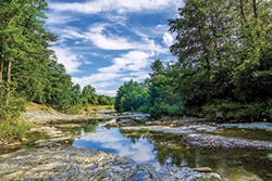
The Springfield Mill Race intake channel is located on the north bank of the Middle Fork of the Willamette River within Clearwater Park. From there it follows a meandering course of approximately 3.5 miles to the northwest, through natural and agricultural lands then past residential and industrial areas into what was once a 30-acre millpond. As it leaves the former millpond area and before discharging into the main stem of the Willamette, the Mill Race passes two blocks south of downtown Springfield (Booth-Kelly site). State Highway 126 and a Union Pacific Railroad separate the Mill Race area from the city center.
Mill Race History and Restoration Background
Springfield’s Mill Race waterway is part natural and part man-made. For more than a century and a half, it functioned as a municipal, agricultural, and industrial resource for the community. In 1985, Georgia Pacific donated the Mill Race and its water rights to the city, and the city has worked ever since to enhance and restore this area. The Mill Race Stormwater Facility is the latest step in the city’s efforts to develop this waterway as a valuable community asset offering economic, recreational, educational, and environmental opportunities.
In 1993, the Mill Race Concept Plan established a community vision for transforming Springfield’s Mill Race into a community asset by preserving and enhancing its vitality for community enjoyment and benefit. The concept envisioned abundant clean water; distinct urban and rural landscapes; access for fishing and canoeing; trails for equestrians, bicycles, and pedestrians; historical and interpretive opportunities; economic revitalization; preservation and enhancement of natural areas; and protection of groundwater resources. Since the adoption of that community vision, city leaders have collaborated with their local agencies and partners to steadfastly support projects aimed at achieving these goals of enhancing environmental quality, recreation, economic development, connection with the past, and community pride.
The City, with support from the US Army Corps of Engineers (USACE), completed the Mill Race Aquatic Ecosystem Restoration Project during the spring of 2013. Constructed in two phases, the project included a new Mill Race inlet from the Willamette River Middle Fork at Clearwater Park, riparian enhancement along the upper reach of the Mill Race, and restoration of the former millpond area including dam removal, rechannelizing, and riparian enhancement along the Mill Race. However, the project did not extend downstream to the Booth-Kelly site.
As part of its cooperation agreement with USACE, the City was obligated to ensure that clean water enters the restored Mill Race from local drainage. To fully comply with the Clean Water Act, Endangered Species Act, and Safe Drinking Water Act, the City took responsibility for improvements to and protection of the entire Mill Race system. Thus, riparian habitat, water quality, and drainage improvements are anticipated for all publicly-owned properties adjacent to the entire Mill Race.
By 2008, the city’s Stormwater Facilities Master Plan had already identified three major projects for achieving these objectives. The Mill Race Stormwater Facility would treat stormwater discharges from the southeast downtown area. This facility would replace 2,000 feet of an existing 48-inch storm pipe with a shallow pond providing treatment by settling and uptake by vegetation. The treatment facility would be constructed on 14 acres of city-owned land and would intercept and treat stormwater from approximately 117 acres of the city’s industrial and commercial areas south of Main Street.
Recreational and Educational Setting and Funding
The Springfield Mill Race is considered a regionally-significant public open space with natural, recreational, and historical attributes. Thus, in addition to improving flow and water quality, Springfield desired to use the Mill Race as a resource for community education and recreation. Preliminary planning for educational and recreational improvements adjacent to the Mill Race occurred as part of the Aquatic Ecosystem Restoration Project.
In 2012, the Willamalane (the local park district) board of directors adopted an updated Willamalane Park and Recreation Comprehensive Plan, which identified a proposed natural area park at the Booth-Kelly/Millpond site, with an emphasis on outdoor education. Additionally, in 2012, voters approved a Willamalane Park and Recreation District bond measure to fund a number of park projects, including development of a multi-use path along the Mill Race from downtown Springfield to the Middle Fork path.
Funding for the stormwater facility project was provided by the stormwater revenue bond sold by the city in 2010, as well as by system development charge funds paid by developers. The City partnered with Willamalane to enable concurrent construction of the trailhead and multi-use path through the site. The Springfield Utility Board also coordinated the installation of a water line in the project reach during the construction of the facility, trailhead, and multi-use path.
Stormwater Facility Design
In 2013, Amec Foster Wheeler developed a feasibility study for the stormwater facility, including the development of three concepts to about the 30% design level. This level of design showed that the proposed project was feasible and that the major design constraints were addressed. In addition, the work on the feasibility study provided a strong understanding of how the treatment facility fits within the larger context of the Mill Race ecosystem restoration, the city, and the region.
From the work on the feasibility study, we understood and appreciated the significance of the Springfield Mill Race as a public open space with habitat, educational, recreational, and historical value. In addition to this facility’s primary stormwater treatment function, the project had tremendous potential and value for community and natural resources benefits. Based on findings from the feasibility study, we understood that this project would be both challenging and rewarding for a variety of reasons.
Site Geology
According to published geologic information, regional geology consists of Willamette and McKenzie River alluvium overlying marine sediments of siltstone, sandstone, and basaltic material from the Little Butte volcanic series. The alluvium is up to 100 feet thick regionally and estimated to be about 50 feet locally. It consists of interbedded sands and gravels with some layers of silt and clay.
The onsite investigations revealed somewhat varying near-surface soil conditions, but confirmed the mapped stratigraphy. In general, explorations encountered a gravelly fill layer overlying clays and sandy gravels. The fill ranged from two to four feet thick and was composed of dense, sandy gravel with cobbles, some silt, and trace organic woody debris. The fill was underlain by an 18- to 19-foot-thick sequence of medium stiff to stiff silty clay. These clay soils did not lend themselves to feasible infiltration for design considerations.
Stormwater Pollutants of Concern
Amec Foster Wheeler compiled historical water quality data for the Mill Race and its industrial stormwater sources. The majority of these samples collected had been analyzed for pH, temperature, dissolved oxygen, Escherichia coli (E. Coli), turbidity, biological oxygen demand, total suspended solids (TSS), total phosphorus, nitrogen, total copper, total lead, total zinc, and oil and grease.
To address data gaps, we began collecting a series of water quality samples in January 2014 and compared results to applicable National Pollutant Discharge Elimination System (NPDES) criteria. Comparing water quality results to NPDES criteria helped identify the pollutants that could be mitigated by the design. During sampling, various field parameters were recorded, including temperature, dissolved oxygen, and pH. Results from the water quality sampling showed that E. Coli, TSS, turbidity, iron, and phosphorus were the main pollutants of concerns. While E. Coli levels were on average below the NPDES limit, there should not be any industrial sources of E. Coli discharging to the Mill Race, and this needed to be reviewed and considered during treatment selection.
Treatment Selection Considerations
Settlement by Wet Pond. One option for treatment at the Mill Race facility was a primary gravity separation or settling process, such as a wet pond or a series of wet ponds. TSS removal performance of this type of treatment facility has been shown to be higher than either extended detention basins (which drain down between storms) or grassy swales (biofiltration), which operate only when flow is present. Settling occurring during quiescent periods between storms is the reason wet ponds have exhibited greater sediment reduction performance than their common alternatives.
The length-to-width (L/W) ratio of the pond is the dominant design element affecting performance, but the wet pond design storage volume also influences treatment performance. For best performance, the facility must be designed so that the volume of the incoming water from a design storm will be significantly less (i.e., less than 70%) than the maximum facility volume. If this design volume can be accommodated, then L/W ratios greater than 3:1 are not necessary.
If this total pond volume cannot be accommodated, then a L/W ratio greater than 3:1 and perhaps as high as 5:1 to 8:1 may be required to achieve adequate TSS removal. Pretreatment wet ponds are common components of this type of treatment facility and are generally smaller than primary treatment ponds, with lower total volume. This suggests that a larger L/W ratio may be required for a pretreatment pond, assuming one is selected as part of final facility design in order to achieve optimal treatment efficiency. Inclusion of lateral baffles with end openings to increase L/W ratio will significantly improve treatment efficiency while minimizing space required to construct a pretreatment pond.
Total suspended solids removal efficiencies of approximately 90% have been documented for well-designed wet pond treatment facilities that follow these design recommendations. Phosphorus removal from wet ponds varies widely between facilities. Some studies show removal as high as 80%, and others as low as 20%. Once again, wet ponds are believed to be superior in nutrient and metal removal when compared to extended detention basins.
Little is known regarding the removal effectiveness of bacteria such as E. Coli by wet ponds. A study in North Carolina examining several different types of best management practices found that the two wet ponds included in the study had an E. Coli removal of approximately 46% for an average incoming geometric mean influent of 2,122 colony forming units per 100 milliliter (mL) (Hathway et. al. 2009). This document also stated that the performance of wet ponds for removing indicator bacteria was quite variable. Two wet ponds in Wilmington, NC, studied by others found reductions of greater than 50% for indicator bacteria (Mallin et. al. 2002). Good solar exposure, though potentially detrimental to water temperature, is thought to aid in bacteria removal.
Biofiltration by Grassy Swale. Although grassy swales are commonly viewed as filters (biofiltration), they are properly classified as shallow basins or biosettlers. Flow through grass swales functions as a treatment device if vegetation remains erect. Erect grass increases the surface area exposed for sediment collection (e.g., on the vegetation), slows flow, and reduces shear stress in the swale, which reduces the swale’s ability to carry sediment. Swale length relates directly to residence time, and although lengths up to 250 feet have been recommended, controlled flow tests with synthetic stormwater found that little additional removal of TSS, phosphorus, or nitrogen occurred with swale lengths beyond 100 feet (Fletcher et. al. 2001). Data from field studies appear inconsistent with respect to the effect of either length or residence time to treatment efficiency. One study found that removal of TSS at residence times of five and 10 minutes was essentially the same (70 and 74%, respectively), but increased to 86% with a residence time of 18 minutes (Kuo et. al. 1999).
Swales designed for treatment appear to give reasonable performance, near 60 to 80% TSS removal, provided the hydraulic residence time in the swale is at least 10 minutes (Khan 1992). Influent concentrations of sediment affect performance, with higher concentrations resulting in higher percent reductions. One study of six swales found that an average influent TSS concentration of 71 milligrams per liter (mg/L) was reduced to an average effluent concentration of 35 mg/L for an overall removal of 51% (Caltrans 2004). It is best to design a shallow, wide swale rather than a deep, narrow one because this provides more vegetation contact and longer residence time. However, width is limited by the ability to spread the stormwater evenly across the cross-section of the swale.
Swales appear to have low effectiveness in reducing bacteria, and in some cases, have the potential for exporting bacteria (Clary et. al. 2008). Potential causes could include that these types of BMPs tend to attract ducks, geese, other wildlife, and domestic pets, which may contribute to bacteria loading. Regardless, swales can still be effective in reducing pollutant concentrations such as TSS, total metals, and other constituents.
Low Impact Development. Low impact development (LID) techniques were evaluated during the design phase. In the parking lot, a flow-through biofiltration rain garden was installed to capture stormwater that fell within the trailhead parking lot. Some large canopy trees were included in this design to shade the wet pond pool. Also, large areas of groundcover including native grasses and shrubs were incorporated. These materials enhance surface infiltration and filtering of surface runoff.
Hydrologic and Hydraulic Analysis
Perhaps the most challenging aspects of the site are its hydraulic constraints. The existing 48-inch diameter pipe was essentially flat, with 0.073% slope and only 1 foot of drop across the site. There could not be an increase in the hydraulic grade line or else upstream basin flooding could occur.
Amec Foster Wheeler’s Flow Duration Design Model (FDDM) was used to simulate hourly inflows to the Mill Race Facility from the 117-acre drainage basin that is 78% impervious surface, based on 59 years of recorded rainfall. FDDM is a continuous hydrologic model developed to calculate hourly runoff using time series from a regionally calibrated Hydrological Simulation Program–Fortran (HSPF) program for a combination of soil and land use. The HSPF computer program was developed by the US EPA for simulating continuous rainfall events over long periods of time (often decades).
The back-to-back nature of real storm events is directly simulated in FDDM, instead of using a single synthetic “design” event. The runoff resulting from hundreds of storms over decades allows development of statistics that are typically used to compare existing versus developed conditions and to compare pre- and post-project flow durations. In this case, FDDM was used to predict hourly inflows to the stormwater treatment facility to calculate how flows would be stored and discharged from the pond and its bypass facility. The volume of runoff that was not treated but that bypassed the facility was calculated by counting the number of hours that overflow appeared in the bypass channel.
The maximum capacity of the 48-inch inflow pipe was estimated to be 45.7 cubic feet per second (cfs) using Manning’s equation and the average slope of the existing pipe along and across the project site. To yield a conservative (higher) maximum inflow, the pipe was modeled as free-flowing and not limited by backwater from the Mill Race. Flow above 50 cfs would require more head on the pipe than is available because flow would back up and cause pooling on the surface. With 4 feet of additional head, the flow is 75.2 cfs. The friction coefficient (Manning’s n-value) was taken at 0.011, which represents a typical published value for high-density polyethylene pipe.
The hydraulics analysis performed for the Mill Race and the treatment facility used the HEC-RAS computer model. HEC-RAS was developed by the USACE Hydraulic Engineering Center. The model is used by FEMA nationwide for floodplain analysis. Initially, a HEC-RAS model was developed for the Mill Race itself based on USACE construction drawings. This model considered 300 cfs as normal flow and 500 cfs as flood conditions for the Mill Race. Both flows were provided by the city.
The Mill Race depths and velocities were determined for these flow rates. The depth corresponding to 300 cfs was used as a downstream condition for a separate hydraulic model of the treatment facility. The depth corresponding to 500 cfs was not used further, as this would be outside the hydraulic performance range of the treatment facility.
The treatment facility model began at the Mill Race and simulated several flows in the outlet and bypass channels. The resulting models verified that control structures in the treatment facility would perform as designed without submergence or reduction in conveyance capacity.
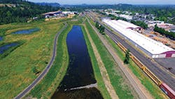
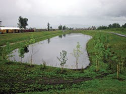
The final design was an adaptation of the largest pond alternative identified in the feasibility study and included construction of a large treatment pond, a grassed drainage swale for both outflows and bypass flows, and daylighting of approximately 2,100 feet of 48-inch pipe. The pond includes both a permanent pool and extended detention. The treatment volume of 6.5 acre-feet corresponds to approximately 131% of the volume of runoff from the 0.83-inch water quality storm.
Outflow from the pipe is intercepted by a sedimentation forebay at the east end of the long, narrow pond. Discharge of treated water goes through a screened orifice structure at the west end of the pond. As the pond fills, water slowly spreads through the entire length of the pond. An overflow weir is located near the pond inflow on the north edge of the sedimentation forebay. Flow over the weir goes to a drainage swale north of the pond that conveys water west to the existing point of discharge to the Mill Race. Treated outflow from the orifice drains through the outlet structure to this swale. A berm separates the pond from the swale and provides 1-foot freeboard above the design water surface elevation of the pond. Grading provides for vehicle access to and along the swale for maintenance, and access to the pipe inflow, overflow weir, and orifice outflow structure.
Landscaping
Plants in and immediately around the treatment pond were selected for their ability to absorb nutrients, heavy metals, and other toxicants from the water (thus cleaning the water). Plants were also selected for their ability to minimize water temperature increases from the open water area of the pond or the urban “heat island” effect or through shading. Low-growing upland grasses or grass-like plants were utilized for the overflow swale that in some areas also doubles as a service road. Plant varieties suited for emergent wet to saturated zones were included. Plant choices were also selected from planting zones based on soil moisture levels. The following plant zones were utilized:
- Wet to saturated: Shallow water to 1 foot above the base of slope
- Moist to dry: Side slopes from 1 to 3 feet above the base of slope
- Dry: Side slopes more than 3 feet above the base of slope plus upland areas
Permitting
Amec Foster Wheeler performed a Wetland and Other Waters Determination and Delineation report that was submitted to the Oregon Department of State Lands (DSL) for concurrence. Two small emergent palustrine wetlands and four ditches were observed within the study area. The four ditches were created from upland and are not connected to any other stormwater feature, wetland, or surface water body and were not considered jurisdictional by the DSL or USACE. DSL did consider the wetlands jurisdictional, and the final design included a mitigation bank as offset.
A joint permit application was submitted to the USACE and DSL. Amec Foster Wheeler also completed a cultural review because of the historic nature of the project area.
The project also required a Union Pacific Railroad right-of-way permit due to the placement of the stormwater facility diversion vault on railroad property for diverting flows from the existing 48-inch pipe into the stormwater facility.
Conclusion
Construction of the Mill Race Stormwater Facility and multi-use path and trailhead was completed in January 2017. The stormwater facility and recreation improvements were opened to the public shortly after during a public grand opening ceremony. This project provides an important example of how “out-of-the-box” thinking can lead to feasible stormwater treatment retrofits where more traditional approaches, which would have required more hydraulic head than were available, would have resulted in no treatment being provided.
References
Caltrans. 2004. BMP Retrofit Program: Final Report. Report No. CTSW-RT-01-050, Sacramento, CA: California Department of Transportation.
Clary, J., J. Jones, B. Urbonas, M. Quigley, E. Strecker, and T. Wagner. 2008. “Can Stormwater BMPs Remove Bacteria? New Findings from the International Stormwater BMP Database.” Stormwater 9(3): 60-67.
Fletcher, T.M., L. Peljo, J. Fielding, T. Wong, and T. Weber. 2001. The Performance of Vegetated Swales for Urban Stormwater Pollution Control. Ninth International Conference on Urban Stormwater Drainage. Reston, VA: American Society of Civil Engineers.
Hathway, J.M., W.F. Hunt, J.D. Wright, and S.J. Jadlocki. 2009. Field Evaluation Bacteria Removal by Stormwater BMPs in North Carolina. World Environmental and Water Resources Congress. Reston, VA: American Society of Civil Engineers.
Khan, Z. 1992. Biofiltration Swale Performance, Recommendations, and Design Considerations. Seattle, WA: Municipality of Metropolitan Seattle.
Kuo J., S.L. Yu, E.A. Fassman, and H. Pan. 1999. Field Test of Grassed Swale in Removing Runoff Pollution. Twenty-Sixth Annual Conference Water Resources Planning and Management, Tempe, AZ. Reston, VA: American Society of Civil Engineers.
Mallin, M.A., S.H. Ensign, T.L. Wheeler, and D.B. Mayes. 2002. “Pollutant Removal Efficacy of Three Wet Ponds.” Journal of Environmental Quality, 31: 654-660.
Acknowledgments
This work was performed under contract with the City of Springfield, OR. Amec Foster Wheeler thanks the City of Springfield and the Willamalane Park and Recreation District for the opportunity to work on this project. Amec Foster Wheeler especially thanks Jesse Jones and Molly Markarian with the City of Springfield and Simon Daws and Vincent Martorello with Willamalane for supporting our work on this project.


