A group of people are wading slowly through high grass under a hot summer sun as they begin a guided walking tour of the Walton Floodplain in Delaware County, NY.
Suddenly, there’s excitement in the air as an eagle perches on a nearby branch hanging over the West Branch Delaware River. The group swiftly changes its focus—and cameras—from the tour to this majestic bird.
It seems the group is no longer interested in what their guide has to say. On the contrary, the group members are an interagency team that is looking over the land because they’re starting a reclamation project that will improve the floodplain’s environment for that eagle, reduce flooding for the local community, and protect New York City’s drinking water.
The Walton Floodplain Reclamation Project is part of the US Army Corps of Engineer’s New York City Watershed Environmental Assistance Program.
“The program funds projects that are protecting the water quality of New York State’s watersheds that provide drinking water to millions of New York City residents and businesses,” says Rifat Salim, project manager with the Army Corps of Engineers, New York District.

Graydon Dutcher, stream program coordinator with the Delaware County Soil and Water Conservation District, leads the team down to the West Branch Delaware River.
On this project, the Army Corps is working in collaboration with the Delaware County Soil and Watershed Conservation District, New York State Department of Environmental Conservation, New York City Department of Environmental Protection, Village of Walton, and Town of Walton.
A floodplain is the land bordering a river. Over the years, the 13-acre Walton floodplain that borders the West Branch Delaware River has been filled with gravel that has raised and hardened the floodplain and degraded the natural vegetation.
Graydon Dutcher, stream program coordinator with the Delaware County Soil and Water Conservation District and the team’s guide on the floodplain tour, says, “The floodplain has been filled through the years one dump truck at a time as a place of easy disposal of materials.”
As a result, when the river floods, the water that would naturally be absorbed, filtered, and transported by the floodplain is unable to do so. Floodwater backs up because of the overfilled floodplain and stays trapped on the streets of the Village of Walton, flooding businesses and homes, especially Delaware Street and the ironically named Water Street.

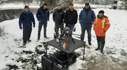
The team at the water’s edge of the West Branch Delaware River
When this high volume of stormwater runoff floods the streets, it sweeps up contaminants and carries them to the West Branch Delaware River, which feeds into the Cannonsville Reservoir. The reservoir supplies 97 billion gallons of water to New York City’s drinking water supply. (See New York City Watershed System sidebar below.)
This project will return the floodplain to its natural state, and as a result will reduce flooding and improve water quality.
“We are going to remove the gravel, creating a more natural floodplain elevation,” says Dutcher. This work will include removing and relocating a New York State Electric and Gas Corp. line to a deeper elevation, and recycling the gravel and moving it outside the floodplain.
During the walking tour, Dutcher points to a McDonald’s golden arches sign several yards away. He notes, “We are at the same height as the golden arches. This is how high the floodplain has grown over the years!”
Dutcher takes the group through a long, muddy path surrounded by high shrubbery leading to the West Branch Delaware River. The team stands along the river’s edge and continues to take photos of the resting eagle perched above the moving river.
The project will include restoring the floodplain’s vegetation. The invasive plant species that the group has been walking through will be removed and grass will be planted. Where the team is standing along the river, says Dutcher, a riparian buffer or hardwood forest is going to be created that will include a mix of native maples, ash, and a mix of shrubs.
“Flood waters will drain from the town’s streets, building rooftops, and parking lots, and filter through the restored vegetation and the riparian buffer before entering the river,” explains Dutcher. The riparian buffer will trap sediment and pollutants like harmful phosphorus and nitrogen and prevent them from entering the river. This will improve the quality of the water, maintain the river’s temperature, and foster the creation of fish and aquatic habitats. The project will treat 2.8 acres of stormwater runoff.
“This project is a big thing in Walton,” says Dutcher. “It benefits the community in several ways.”
The project will lessen the damages of flooding. When completed, it will provide flood reductions for a 100-year storm event. It will also offer protection from lesser, 10-year storm events. The project will also connect and drain the newly built green space in the center of Walton’s Main Street. Dutcher adds that the project, which is expected to be completed by 2018, will also potentially give the land back to the community for other uses like athletic fields and parks.
That eagle never left the branch the entire time the team was walking the floodplain, and it seemed to be keeping a steady eye on them. Some in the group saw it as nature’s way of reminding them to keep focused on this project that has multiple benefits for locals, city dwellers, and eagles who just happen to make Walton their home.
New York City Watershed System
The New York City watershed region encompasses approximately 2,000 square miles of land north of New York City. The land includes three watershed systems—the Catskill, Delaware, and Croton systems—that are located in the counties of Greene, Schoharie, Ulster, Sullivan, Westchester, Putnam, Dutchess, and Delaware.
A watershed is an area of land that catches rain and snow that drains or seeps into a marsh, stream, river, lake, or groundwater. This water eventually gets stored in reservoirs, a place where water is collected and kept for use when wanted, such as to supply a city.
The New York City Watershed System provides more than 90% of New York City’s water supply, or water for approximately 9.5 million people. New York City makes sure that this water is safe by treating it at the source rather than building a costly filtration plant. The source is the land that surrounds the streams, rivers, lakes, and reservoirs.
“In 1996, all of the municipalities in the New York City watershed region came to an agreement. They wanted to avoid the creation of a huge filtration plant. Instead of a plant, they agreed to have small projects throughout the region to provide the public with clean water with minimal filtration. This is how our New York City Watershed Environmental Assistance Program came about,” says Rifat Salim, project manager with the US Army Corps of Engineers.