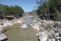
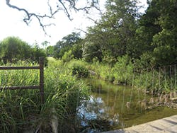
Stream buffers are natural areas adjacent to streams and waterways that remain free of development, construction, or other alterations and play an important role in maintaining predevelopment water quality. The riparian vegetation stabilizes stream channels, provides terrestrial and aquatic habitat, slows runoff rates, reduces runoff volume, and filters development runoff.
We can contrast stream buffers with stormwater management measures (SMMs). The North Carolina Forest Service defines SMMs as constructed measures designed to be an effective or practicable means of preventing or reducing the amount of pollution generated by nonpoint sources to a level compatible with water-quality goals or requirements.
Although stormwater control measure (SCM) is becoming the accepted term for a multitude of measures and replacing the term best management practice (BMP), from my viewpoint we do not “control” stormwater. Our country has experienced recent floods on the local and regional scale that far exceed engineered projects’ ability to control floods and enhance water quality. Add in the issues of proper construction and effective long-term maintenance to further challenge the notion that these measures “control” stormwater. Instead, we attempt to “manage” stormwater through changing conditions and climate to produce public safety, economic, and environmental benefits. In this article, the term stormwater management measure is used to describe ponds, basins, filter systems, proprietary devices, etc., that are designed to manage stormwater rate, volume, and quality.
The Importance of Headwater Streams
The nation’s rivers and lakes originate from a network of small and headwater streams that are known to significantly influence the quantity and quality of downstream waters. In addition to providing water-quality benefits, these small streams mitigate flooding, generate local recharge, recycle nutrients, provide habitat for plants and animals, and sustain the biological diversity of rivers, lakes, and estuaries. It is in this zone that stormwater runoff has the most contact with the land surface through shallow flow and where much of the streams’ filtering processes take place. Often, surface and groundwater interact in this area, even in seasonal and intermittent streams.
It has been understood that the Clean Water Act will provide protection for all the waters of the United States. Regardless of this impression, many small streams have been destroyed, filled, or severely altered through mining, agricultural, and development practices.
From local and regional studies, we know that headwater streams make up at least 80% of the nation’s stream network. This indicates the vital role they play, yet it is difficult to fully appreciate their widespread coverage because often they are not visible on maps used in regulatory practices, which can affect their ability to be protected. Changes, such as replacing the stream with a storm drain and filling the riparian area, eliminate the numerous stream benefits and increase the rate and volume of runoff onto downstream landowners. This hydrological change further scours the channel and accelerates stream velocities, which promote stream degradation, widening, extensive habitat loss, and further flooding. Increased sediment volumes from accelerated stream erosion impair water quality, affect navigation, and increase water filtration costs for municipalities. A transformation of the natural riparian system to a degraded gully can negatively affect recreational uses. Finally, land-use change directly adjacent to the stream further degrades the natural functions and can introduce invasive species that adversely affect the biological diversity in the riparian zone.
In summary, because small streams are the primary source of our nation’s waters, changes that degrade these headwater systems affect rivers and lakes downstream, often requiring drainage improvement projects and other measures to protect the public, infrastructure, and the environment.
Development and Stormwater Management Design
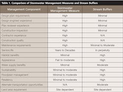
Site and subdivision development designers have many options to select the SMMs to meet the local jurisdiction’s stormwater management requirements. However, before one jumps right into the SMM toolbox to pull out the latest option or rely on the regulatory favorite, one should first consider the use of stream buffers to reduce construction disturbance, maintain the natural stream character, and minimize short- and long-term water-quality impacts. Stream buffers are a low-impact development (LID) approach because they cause the design of the development to minimize its impact to the terrestrial and aquatic systems, through such means as minimal cut and fill, preserving trees, and working with the natural topography and vegetation to maximize the natural system function. Buffers provide everyday ecosystem service benefits when compared to SMMs that function only during rainfall/runoff events. See Table 1 for a comparison.
There are many structural control measures and devices with intricate design, construction, and maintenance requirements that we designers and engineers know can be absorbed by the process. As we know, the best design plans without proper construction and maintenance execution can lead to years of costly improvements and/or non-performance in treating stormwater runoff. Buffer zones do not have these challenges because they are simple in design and they allow or help natural processes to manage stormwater. The helping comes from the use of volume controls (conventional, LID, green infrastructure) to manage the frequent storm events to maintain geomorphic equilibrium that protects the buffer zone from the impacts of hydrologic change generated by upland development.
As noted above, the design, permitting, and construction of common stormwater management measures requires significantly more design skills, local jurisdiction experience, and knowledgeable contractors to properly install these systems to ensure performance and minimize maintenance. The relative ease in establishing buffer zones along the riparian corridor allows this practice to be incorporated into development projects and offers the supplementary benefits of water supply enhancement, floodplain management, and alternative transportation options.
Central Texas Stream Buffers
In central Texas, stream buffers have been part of the regulatory requirements by the city of Austin since the 1980s and have served as the model for other regulatory programs that protect surface and groundwater supplies. The criteria define the buffer width based on the contributing drainage area at the point of interest. As the drainage area increases, the buffer zone also increases in size. The Lower Colorado River Authority’s (LCRA) Highland Lakes Watershed Ordinance and the Texas Commission on Environmental Quality’s Edwards Aquifer Option Enhanced Measures begin buffer zones at a drainage area of 5 acres, while the city of Austin buffer zones begin at a drainage area of 64 acres. The combination of these regulatory programs protects the drinking water supplies for Austin and surrounding communities.
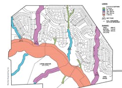
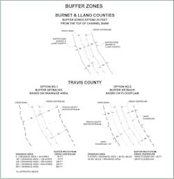
Michael Barrett, Ph.D., P.E., D.WRE, author of the Texas Commission on Environmental Quality (TCEQ) Optional Enhanced Measures for the Protection of Water Quality in the Edwards Aquifer, included measures that were targeted toward nondegradation to protect federally listed endangered or threatened species. Criteria components are stormwater quality treatment, stream buffer zones, and construction erosion controls to mitigate the impacts of urbanization on water quality. The TCEQ document guides the process to delineate creek buffers as the first step in the development process. An example of stream buffers in a planned development project is shown in Figure 1, which illustrates the varying buffer width based on the contributing drainage area.
Barrett offers the following: “While stream buffers provide water-quality enhancement through filtering of urbanized runoff before it reaches the stream, the secondary benefits are significant and include floodplain management (keeping structures out of the floodplain), stream habitat protection, managing stream temperature, wildlife benefits, and providing a natural setting for hike and bike trails and other recreational features.”
Another central Texas regulatory program, the LCRA Highland Lakes Watershed Ordinance (HLWO), manages stormwater runoff from new development, quarries, and mines in portions of three central Texas counties (Figure 2). The HLWO encompasses an area of about 1,100 square miles in the watersheds contributing to the Highland Lakes. The Highland Lakes serve as a major recreational attraction and are the water supply for over one million people, including the city of Austin.
At 5 acres of drainage area, it can be difficult to determine if a waterway exists, so the LCRA defines a creek as a well-defined channel that can convey running water. Creeks are determined to begin where water concentrates, so in an area with gentle topography it could be 10, 15, or more acres until a defined channel is found. In this case, the creek buffer would not begin until this point is defined on the development plan. If needed, LCRA regulatory staff work with the designer through topographic maps and onsite review to define the start of a headwater stream, which then establishes the buffer width.
The HLWO was adopted in 2006 and went through an extensive public review process in 2014, resulting in no changes to buffer zone requirements. LCRA engineering supervisor Erik Harris, P.E., manages the HLWO program. “During the planning review process, site conditions may require our permit staff to meet the design engineer in the field to verify the beginning of a creek that then establishes the buffer zone,” says Harris. “This can be necessary in the upper headwaters or in areas of flatter terrain.”
Harris notes that it is important for the developer to define the creek buffer on the plat and have it recorded as part of the subdivision approval process. During construction, inspectors ensure that the buffer zones are protected from construction impacts and that permitted road or utility crossings receive additional erosion protection and enhanced restoration efforts.
Harris also says educational materials for developers and homebuilders are valuable tools used to inform landowners of the purpose and limitations of creek buffers. Inspectors work with landowners to maintain and enhance buffer zones rather than allowing landowners to “annex” the buffer zone behind their home to create a larger backyard. The HLWO allows homeowners to add low-impact enhancements in the buffer zone but prevents large-scale buffer zone modifications.
The buffer width is established from the creek centerline and varies based on the contributing drainage area. The LCRA offers a floodplain option as an alternative to prescribed setbacks at the choice of the design engineer/developer. The buffer can be established as the 100-year future land-use floodplain plus 25 feet; thus, for larger watersheds, the buffer zone can be significantly less than the prescribed setbacks in steeper topographic regions.Table 2 shows a comparison of buffer zones in central Texas (LCRA, city of Austin, and TCEQ).
To provide flexibility in development design, certain allowances are provided that generate minimal buffer zone impacts, such as a limited number of utility and roadway crossings that are perpendicular to the stream. Low impact development parks can be allowed and should be limited to trails, picnic facilities, and similar construction that do not significantly alter the existing vegetation. Parking lots and roads significantly alter existing vegetation, are not considered low impact, and should be placed outside the stream buffer.
Storm Drain Outfalls to Buffer Zones
Traditional subdivision design relies on the street network with curb and gutter directing runoff to storm drain inlets that connect to the storm drain pipe system. The design philosophy has been to convey the stormwater runoff quickly and safely away from the subdivision. As the storm drain runs downstream, more and more area contributes to the system, increasing the pipe size. The stormwater is conveyed directly to the creek, which tends to generate localized erosion problems in the streambed and along the creek banks. If the storm drain line is terminated at the buffer zone, the erosion issues found at creek outfalls is translated to the buffer and leads to buffer degradation, including a new channel that directly connects the storm drain outfall to the natural stream, negating the buffer zone benefits.
To maximize stormwater treatment, retain the upland development impervious cover disconnection, and ensure a healthy riparian corridor, it is important for storm drain outfalls to discharge in a sheet flow manner at or along the buffer’s edge. This provides a challenge in development design as the storm drain exit velocities can be in excess of 10 feet per second, and typical riprap outfall measures are not sufficient to diminish the water energy and spread the flow to protect the vegetation and soils. To achieve this objective, the typical storm drainage design should be modified to decrease the size and corresponding depth of the storm drainpipes to increase the number of outfalls to the buffer. Thus, the more uniform distribution of subdivision runoff to the buffer begins in the storm drain design and does not rely only on end-of-pipe measures.
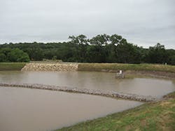
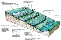
The next step is to convert the concentrated point discharge to sheet flow along the buffer and to maintain that sheet flow for the entire buffer width. Murfee Engineering Inc. in Austin, TX, developed an outfall design that discharges parallel to the contour and uses several levels of berms and vegetative barriers to promote infiltration and treatment as water slowly cascades toward the creek. Figure 3 illustrates how this approach capitalizes on the biological abilities and physical attributes of specific hedge-forming plants and native grasses in combination with rock berms and alternating strips of native grasses and stiff grass hedges. The stiff grass hedges form a vegetative barrier to impede the water, maintain sheet flow across the vegetative filter, and enhance sedimentation and infiltration. This approach requires less grading and disturbance of riparian vegetation than more traditional end-of-pipe treatment methods. Installation of the berm and hedges can be tailored to preserve existing trees and vegetation and maintain an aesthetically pleasing environment.
This system has been used for more than a decade in new subdivisions constructed within the sensitive Edwards Aquifer Recharge Zone and has demonstrated the ability to be a low-maintenance, self-sustaining SMM to enhance stream buffer performance. Finally, on some projects, the on-slope terrace treatment system has been approved as the primary water-quality treatment method to manage runoff and has reduced or eliminated the need for upstream sedimentation-filtration or retention-irrigation water-quality treatment basins.
Other Buffer Zone Benefits
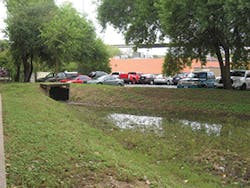
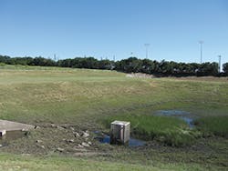
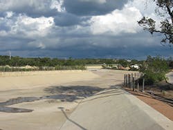
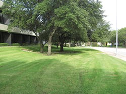
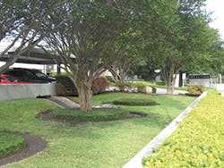
Buffers are especially important in high-growth, developed, sprawling communities. Texas has many of the fastest-growing counties and cities in the US, which sometimes leads to complete creek channelization, as shown in the photographs of a creek north of San Antonio.
A development that converts a natural stream system to a concrete or trapezoidal channel shortens the time of concentration, creating more-rapid runoff, and therefore requires larger detention basins to manage peak flow rates. Thus, retaining the existing stream system to the headwaters can reduce the need for detention ponds and lower construction costs. In addition, this costly channel project increases evaporation, heats water in the stream, and prohibits recharge. Stream buffers play a key role in preventing the conversion of natural drainage ways to constructed systems that offer no habitat value and negatively affect community appearance.
Community benefits of buffer zones also connect directly with economic growth in small cities. A recent article by the Initiative for Competitive Inner Cities (ICIC) highlighted a multi-year research effort by David Ivan of Michigan State University, at the National Main Streets Conference. One of the findings in laying the groundwork for sustainable economic futures is investing in “creative infrastructure,” making the community more attractive for residents and businesses as they compete for new and innovative job-producing entities. An important part of this process is creating a strong equality of place, where communities embrace their natural resource assets that are unlike those of any other community, leading to a unique and individual character that can be promoted to entrepreneurs.
Local governments can delineate stream buffer zones in their community and stormwater master planning processes that can connect directly with the parks and recreation trail planning to develop multi-objective benefits. When communities are considering hike and bike trail implementation, stream buffers can be an important component of alternative transportation routes to increase bike mobility and reduce automobile use. In areas of considerable topographic relief, there can be many creeks with headwater protection yielding multiple transportation routes to provide direct access to watershed residents, thus encouraging bike use and improving safety as bicyclists can use trails rather than roads.
Stream buffers perform as an insurance policy during construction to limit construction-related discharges to receiving streams. Over the long term, the wider buffers produce groundwater well setbacks that reduce the potential for water withdrawals from the subsurface flow, which allows groundwater to flow downstream to help sustain habitat and the aquatic system.
As noted earlier, stream buffers effectively manage runoff rate and volume at minimal cost to the local jurisdiction, because maintenance is limited when compared to constructed channels. It’s possible that stream buffers’ floodplain management benefits equal water-quality treatment aspects of filtering. Storms can overwhelm and damage SMMs, while buffers resilience allows them to adapt and respond to major flood events. By keeping homes and businesses outside of the floodplain or high-energy flows of the floodway, stream buffers are an important consideration in sound floodplain management practices.
Stream Buffers As a Standalone Measure
Stream buffers cannot be the only stormwater management measure in a developing watershed due to hydrologic change caused by urbanization. New impervious cover and “efficient” storm drain systems have been proven to severely degrade natural stream systems through the increase in runoff volume, rate, and frequency of bankfull events. This leads to significant habitat loss, extensive channel adjustment affecting existing infrastructure, and large quantities of sediment conveyed to receiving rivers and lakes, further adversely affecting navigation, water supplies, and water quality. Research across the country has found that the channel-forming flow for streams in undeveloped watersheds is in the range of the one- to two-year storms. With urbanization, these storms can generate peak runoff rates five times greater than an undeveloped site, with bankfull events occurring numerous times throughout the year.
In an effort to evaluate the stream protection benefits of its water-quality treatment ordinance, the city of Austin conducted a study to define the erosion potential based on volume control. Mike Kelly, P.E., managing engineer in the city’s Watershed Protection Department, says, “The city water-quality volume requirements, of one-half inch of runoff volume plus 0.1 inch of runoff volume for each 10% increase in impervious cover greater than 20%, reduced the long-term stream power from developed conditions to levels found in undeveloped watersheds. Our criteria require that the water-quality volume be released over a 48- to 72-hour period. This extended detention helps protect urbanizing streams from accelerated and large-scale degradation and widening.” It turns out that the water-quality design volume developed more than 20 years ago to improve runoff quality has the added benefit of managing the channel-forming flows.
Kelly also notes that stream buffers can generate significant benefits, even in existing urbanized areas. “Buffer zones can serve as a standalone protection measure in older urbanized areas where the channel erosion from development has mostly taken place,” he says. “The buffer zone aids in the stabilization of incised creeks and can be enhanced through initiating [no-mow] grow zones to stabilize the creek banks. By allowing creekside vegetation to grow, the stream is protected from higher velocities due to the increased roughness provided by the vegetation. Additionally, since the vegetation is allowed to grow, the root systems are able to develop, holding the soil in place. We applied this approach while working with a neighborhood to avoid constructing a $1.5 million channel improvement project. The creekside residents were pleased with their stretch of native restored creek.”
Summary
With the challenges of constructed stormwater management measures, this article describes the stream buffer approach to manage runoff and protect natural stream systems from excavation, filling, or conversion to constructed storm drain systems. SMMs must withstand the test of time including floods, droughts, poor maintenance, invasive plants, structural failures, and geotechnical challenges, while resilient buffer zones can recover through natural processes.
Stream buffers are the simplest measure to design and implement, and when combined with volume control for the channel-forming flow can serve as the foundation of a comprehensive stormwater protection approach that yields water supply, floodplain management, recreational, and habitat benefits.
So, designers, reach for the stream buffer tool first when laying out your projects to yield long-term stormwater management benefits. Regulators, consider stream buffers combined with simple runoff volume controls when designing new codes and criteria to protect water quality, keep homes and businesses out of harms’ way, enhance recharge, and create attractive developments that work with the natural riparian zone while minimizing your community’s stormwater management maintenance requirements.
References
City of Austin. 2013. Land Development Code. Austin, TX, Department of Planning and Development. September 2013.
Lower Colorado River Authority. (n.d.). Highland Lakes Watershed Ordinance Water Quality Management Technical Manual (5th ed.).
Meyer, J. L., L. A. Kaplan, J. D. Newbold, D. L. Strayer, C. J. Woltemade, J. B. Zedler, R. Beilfuss, Q. Carpenter, R. Semlitsch, M. C. Watzin, and P. H. Zedler. 2003. Where Rivers are Born: The Scientific Imperative for Defending Small Streams and Wetlands. Sierra Club and American Rivers.
Stroud Water Research Center. 2008. Protecting Headwaters: The Scientific Basis for Safeguarding Stream and River Ecosystems. www.stroudcenter.org/research/PDF/ProtectingHeadwaters.pdf.
Murfee, George. and James Scaief. 2004. “Subdivision Design to Maximize Utilization of Stream Buffers.” American Water Resources Association Summer Specialty Conference, 2004.
Texas Commission on Environmental Quality. 2007. Optional Enhanced Measures for the Protection of Water Quality in the Edwards Aquifer (Revised).
