By Andrew Walker, PH, CFM and James Pearson, PE
John Fitch Highway is a major commercial roadway in the north-central Massachusetts city of Fitchburg. First developed in the 1950s with vehicular traffic in mind, large swaths of the area were covered in impervious roads and parking lots. To make way for that development, nearby Baker Brook was completely rerouted, leaving the road and much of the current surrounding commercial development within the brook’s 100-year floodplain so that large portions of the area now regularly flood at least once a year. Climate change-driven increases in future precipitation are expected to exacerbate the flooding damage and disruptions in the area, making a redesign of the area critical to making the community more climate resilient.
Improvements Begin
Using a grant from the Commonwealth of Massachusetts’ Municipal Vulnerability Preparedness (MVP) Program, the city began addressing the chronic flooding of the John Fitch Highway corridor.
In the initial phase of work, the city and its consultant developed a hydrologic and hydraulic (H&H) model of Baker Brook and its upgradient watershed to identify specific flood prone areas in and near John Fitch Highway and abutting properties. The goal was to be able to anticipate worsening flood impacts under future climate scenarios and make broad recommendations regarding channel modifications, land use regulations and potential upstream storage projects that could improve the resilience of existing and future development in the area.
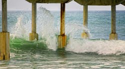
During large flood events, Baker Brook, like most waterways, seeks access to its floodplain to supplement its channel’s hydraulic capacity. Model simulations confirmed what the city had observed on the ground: such a relief valve already exists. When Baker Brook overtops, a significant portion of its floodwaters flow through the 7-acre John Fitch Plaza parking lot, following the approximate original alignment of Baker Brook before it was relocated. This low-lying parking lot serves as a secondary channel during flood events.
Simulations were conducted of various potential riverbank modifications, widening of downstream culvert/bridge crossings, and other solutions aimed at increasing the brook’s hydraulic capacity. These simulations determined that the most effective solution from a hydraulic perspective was to regrade the plaza’s parking lot to accentuate and improve the brook’s access to this secondary channel while keeping floodwaters away from buildings.
H&H model simulations also indicated that while some modest flooding of the John Fitch Highway area occurs due to Baker Brook jumping its bank, most flooding results from overwhelmed catch basins and storm drains in the roadway itself. This suggests that flooding will need to be alleviated using a two-pronged approach: reduce flooding in and along Baker Brook, and expand the capacity of the stormwater system in and upgradient of John Fitch Highway.
The H&H model also evaluated preliminary concepts to reduce the volume and peak rate of runoff entering Baker Brook from its watershed. Concepts included creating increased storage capacity in the city’s existing upgradient drinking water reservoirs and decreasing impervious cover. The increased upgradient reservoir storage concept was shown to do relatively little to reduce downstream flooding given the constraints of their existing use. Watershed-scale reductions in impervious cover, however, were deemed to be quite effective but difficult to achieve in the short-term.
Under a second phase of work, the H&H model was used to evaluate the benefit of constructing green infrastructure (GI) and low impact development (LID) projects throughout the watershed. This detailed evaluation of several dozen GI opportunities indicated some significant flood reduction benefits on the local or neighborhood scale but only modest reductions in and along Baker Brook.
Given its proximity to Baker Brook as well as its identification as a problem area for localized flooding, John Fitch Highway was the focal point of the next phase of the work. This phase prioritized improvement of stormwater management as part of an overall roadway modernization project. In its existing condition, stormwater is managed by a conventional urban collection system consisting of catch basins, manholes and pipes that discharge to Baker Brook. Most of the stormwater that discharges into the brook is untreated, leaving opportunity for water quality improvement as well. The overall watershed study showed promising results for the implementation of green stormwater infrastructure, so such features were identified early in planning the John Fitch Highway project.
It should be noted that since the H&H study showed that flooding from Baker Brook is symptomatic of larger basin-wide problems, the GI improvements to John Fitch Highway are being implemented as a first incremental step in what will ultimately need to be a longer phased approach to basin-wide improvements. The infrastructure improvements associated with the roadway will be targeted to address localized flooding and drainage concerns that originate from the roadway itself.
Specific Flood Reduction Techniques
One of the key considerations in selecting GI components was the amount of available physical space. Components had to fit within the roadway’s existing right-of-way while competing for space with travel lanes and pedestrian and bicycle pathways. Landscape strips and proprietary structural components along the edges of the road were created to work in tandem and allow them to function as efficient stormwater treatment units. This proposed stormwater management strategy was designed to meet capacity and water quality improvement objectives using several main components from ACF Environmental, a Ferguson Waterworks company:
- Rain Guardian Turret
- Rain Guardian Bunker
- PreTX pretreatment device
- FocalPoint biofiltration system for treatment, augmented with R-Tank Detention Systems
The primary pretreatment device for the system is a Rain Guardian Turret, along with two alternatives for situations where the turret was found unsuitable. In situations where the watershed draining to the biofiltration system exceeds 0.25 acres, the larger capacity PreTX pretreatment device replaced the Rain Guardian Turret. The alternate pretreatment device of a Rain Guardian Bunker was used where there was not enough room for the Rain Guardian Turret. In all instances, these compact structures allow for adequate stormwater pretreatment within the limited green space along the highway.
Following pretreatment, stormwater is designed to flow into shallow topographic depressions with the modular bioretention systems that capture and hold stormwater runoff, allowing it to slowly infiltrate through an engineered soil media. Bioretention systems provide water quality benefits with pollutant removal by plants, soil, and microbes.
In addition to 80% or greater total suspended solids (TSS) removal with a vegetated filter strip, bioretention can remove other pollutants, including 60% or greater phosphorus, 48% or greater nitrogen (if soil media is at least 30 inches in depth), and 40-90% of metals (copper, lead, zinc, cadmium). Plantings will uptake water and nutrients in the runoff to reduce nutrient loads to Baker Brook. The bioretention systems will be installed within green spaces along the highway to directly treat runoff from surrounding impervious surfaces.
In addition to the added storage volume provided by the aboveground topographic depressions of the bioretention cells, R-Tank detention systems will be used to provide additional underground storage volume at each bioretention area. R-Tanks are modular cube-shaped underground stormwater chambers that detain stormwater during rain events. Outlet control structures, fitted with beehive grate inlets to prevent trash and debris from entering the systems, will be installed within the modular bioretention areas. The grate elevations will be set to allow for 6-8 inches of ponding depth within the bioretention system and designed to capture smaller storm events. During larger storm events when the capacity of the bioretention areas is exceeded, stormwater will overflow into the beehive drain inlets and will be piped underground to the R-tank detention chambers.
To prevent surcharging of the system, the R-Tanks will be fitted with outlet pipes connected to regular catch basins along John Fitch Highway.
These modular systems were selected for their smaller footprint than traditional bioretention cells, with comparable pollutant removal rates.
Moving Forward
The work done thus far in the Baker Brook watershed has been aimed primarily at reducing localized flooding from runoff within the John Fitch Highway roadway itself, while also identifying the challenges associated with flooding from Baker Brook. Final design of the GI improvements to John Fitch Highway is proceeding using ARPA funds, with construction to be funded by Transportation Improvement Program (TIP) funds through the Massachusetts Department of Transportation. Going forward, the work will serve as a starting point for the city to consider additional projects placed strategically throughout the basin that can also potentially make them eligible for additional grant funding.
Also, the H&H model that was developed is now being used in support of several culvert replacement projects. The goal of these projects is to reduce the frequency and severity of overtopping of roadways and improve their resilience to flooding. By reducing this flooding, it will also help improve water quality in the city’s downstream drinking water reservoir. By implementing these and other projects throughout the basin, the City of Fitchburg will be able to incrementally reduce flood hazards associated with Baker Brook. The model has been, and will continue to be, used to evaluate GI/LID projects in the watershed and to study and inform updates to local stormwater management ordinances and improvement projects.
Andrew Walker, PH, CFM and James Pearson, PE are Technical Leaders in the Water Practice at Weston & Sampson. They can be reached at [email protected] and [email protected], respectively.