Editor’s note: This article first appeared in the May-2016 issue of Stormwater.
In 2014, EPA began a project seeking design and construction of two green infrastructure stormwater best management practice (BMP) projects on Cape Cod in Massachusetts to serve as a model for promoting public awareness and building public support for problems and challenges associated with stormwater. The primary objectives were to design and construct two green infrastructure stormwater BMPs to treat nitrogen, and to monitor both BMPs for a period of years to evaluate stormwater flows and water-quality parameters.
Locations
To seek interested communities, EPA initiated a preliminary site selection process that targeted eight southern Cape Cod communities with stormwater draining to Nantucket Sound. Each community was responsible for identifying potential sites on publicly owned property that would be suitable for BMP construction. Ideal sites would be suitably large enough for BMP construction, be located close to waterbodies along the south coast of Cape Cod, have an existing municipal separate storm sewer system (MS4) draining a large watershed in close proximity, and have public visibility and space for informational signs and/or kiosks. Communities must also be willing to operate and maintain the BMPs, and provide in-kind services to help the project succeed. Additional consideration would be given to proposed locations draining to impaired waterbodies or those with an approved total maximum daily load (TMDL) for nitrogen.
EPA then performed a detailed review on all proposed sites to determine the best candidate locations. Based on the above criteria, two potential locations were selected, one in Barnstable and a second in Chatham. The sites are as follows:
- Barnstable: Gateway Marina/Hyannis Inner Harbor park area located near the intersection South Street and Pleasant Street. This location abuts an existing drainage line that discharges to the Hyannis Inner Harbor, which is listed on the Massachusetts Final Year 2012 Integrated List of Waters as a Category 5 Impaired Waterbody (Segment ID: MA96-82) for fecal coliform and total nitrogen.
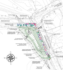
- Chatham: An undeveloped parcel located at the intersection of Oyster Pond Furlong and Absegami Run. This location abuts an existing drainage line that discharges to Oyster Pond, which is listed on the Massachusetts Final Year 2012 Integrated List of Waters as a Category 4a Impaired Waterbody (Segment ID: MA96-45) with TMDLs prepared for both fecal coliform (EPA ID# 36772) and total nitrogen (EPA ID #36219).
Once selected communities and sites were finalized, EPA selected a design team consisting of two consultants to provide a turnkey solution for each location. Selected firms consisted of the following:
- WaterVision LLC of Acton, MA, was responsible for overall project implementation, budgeting, educationand outreach, and sampling program design.
- Comprehensive Environmental Inc. (CEI) of Marlborough, MA, was responsible for project design, BMP construction, and development of an operation and maintenance plan for each location.
After a kickoff meeting with EPA and separate meetings with each community, the design team began to design and size BMPs at each location. Using a combination of information provided by each town and desktop analysis of the surrounding area, CEI assessed the estimated total watershed size, land usage and impervious area, and general layout of the contributing drainage system. Both sites are in urban settings with considerably impervious watersheds. The Barnstable location had an estimated 6.9-acre watershed, of which approximately 3.5 acres was classified as impervious (51%), while Chatham had an even larger estimated 16.9-acre watershed with approximately 5.7 acres of impervious area (34%).
Site Constraints
Potential BMP storage is controlled by several factors, primarily available space for construction and depth to groundwater, which serve to limit potential BMP space in three dimensions. The entire parcel at the Barnstable location totaled approximately 0.35 acre; however, this location is an existing park area with a brick walkway serving to connect an overflow parking area with the ferry terminal. Stakeholders wished to preserve the walkway and public access portion of this area, thereby restricting available surface space to approximately 0.15 acre.
The Chatham location is much larger, totaling several acres in size. However, an existing drainage ditch traverses the middle of the site. This ditch also has wetlands associated with it, and thus is regulated under the Massachusetts Wetland Protection Act as well as local bylaw requirements. As such, available space is restricted to approximately 0.29 acre of surface space, nearly all of which is located within regulated wetland buffer areas. Based on the location of each site (close to the harbor and close to wetlands), groundwater depth was expected to be shallow. To determine actual depth to groundwater, CEI performed onsite soil borings at each location, which indicated that groundwater was very shallow, at approximately 1 to 2 feet below the existing ground surface. An important requirement for gravel wetland systems is to avoid mixing between stormwater for treatment and in-situ groundwater. Due to the shallow groundwater system, the system will have to be lined with an impermeable barrier to prevent mixing.
BMP Choice
Because of the highly visible location within the park at Barnstable and the public demonstration and outreach component of the project, BMPs had to be both functional to treat stormwater and aesthetically pleasing. BMPs such as a gravel wetland are highly functional, but less aesthetically pleasing, whereas a bioretention rain garden is visually appealing, but generally is not capable of treating the required volume of stormwater from the large contributing watersheds associated with this project. Therefore, a hybrid bioretention and gravel wetland system was chosen for implementation at each site, combining the aesthetic component of a bioretention system with the storage and treatment capacity of a gravel wetland. The BMP would generally consist of an aerobic surface bioretention system capable of ponding a large volume of stormwater and an anaerobic subsurface gravel wetland cell. This aerobic-to-anaerobic treatment train is critical to the removal of nitrogen.
This BMP is designed to mimic a portion of the nitrogen cycle in a microcosm environment. (See the sidebar on the next page.) When nitrogen in stormwater first enters the surficial bioretention area, organic nitrogen is converted into ammonium by molecular organisms via the nitrogen fixation process. Positively charged ammonium molecules stick to the negatively charged soil particles where some is absorbed into plant root systems through the assimilation process. Excess ammonium is converted into nitrates and nitrites by aerobic bacteria located in the upper soils areas through the nitrification process. Negatively charged nitrate and nitrite molecules are then flushed into the lower anaerobic where they will undergo denitrification. Here, microorganisms convert nitrates and nitrites into gaseous forms of nitric oxide, nitrous oxide, and ultimately nitrogen gas, and it is eventually released back into the atmosphere, completing the cycle.
Sizing
The design team was responsible for sizing the BMP for stormwater treatment. Due to the large size of contributing watersheds, BMP sizing would have to be maximized to the extent practical as allowed within the site constraints outlined previously. Early in the design process, the 1-inch water-quality volume (WQv) represented a target treatment volume for each site, depending on available room for treatment at each site. Conservatively assuming that 100% of precipitation translates to runoff on impervious surfaces, the WQv for each site is calculated as follows:
- Barnstable WQv = 1 in. * (3.5 ac.) * (43,560 ft.2/ac.) * 1 ft./12 in.) = 12,705 ft.3
- Chatham WQv = 1 in. * (5.7 ac.) * (43,560 ft.2/ac.) * 1 ft./12 in.) = 20,691 ft.3
Due to the substantial water-quality volumes, it quickly became evident that the large contributing watersheds combined with limited available room for BMP construction would make this target infeasible. Fortunately, nitrate and nitrite are highly soluble, which allows BMPs designed for control of nitrogen to be designed for smaller volumes than might be designed for other pollutants, such as total suspended solids, bacteria, or phosphorus, or for the control of flooding. Previous research by the University of New Hampshire Stormwater Center and others indicated that constituents such as nitrate (NO3-) and nitrite (NO2-) are heavily first-flush weighted (i.e., the majority of the pollutant mass (> 80%) is delivered in the first part of the storm event).
Therefore, systems designed for storms smaller than the WQv can provide effective treatment of nitrogen by controlling, capturing, and treating runoff from relatively small-scale events (e.g., 0.2- to 0.4-inch rainfall events) and the early portions of larger storm events while safely bypassing excess stormwater.
Based on available space at each location, subsurface gravel wetland cells, or internal storage reservoirs (ISRs), were designed to be as large as possible while still maintaining good design practices. This included considerations such as minimizing environmental resource area disturbances where possible, maintaining side slopes no steeper than 2:1, and allowing access for maintenance. Final internal storage reservoir dimensions were designed as follows:
- Barnstable ISR: 16 feet wide by 100 feet long, 2 feet deep
- Chatham ISR: 22 feet wide by 120 feet long, 2 feet deep
Per the Evaluation and Optimization of Bioretention Design for Nitrogen and Phosphorus Removal prepared by the UNH Stormwater Center in June 2013, a gravel wetland typically contains about 25% of the design storage volume (DSv) in the crushed stone internal storage reservoir. Therefore, the total design storage volume is equivalent to four times the internal storage reservoir volume (ISRv). Using a stone reservoir void ratio conservatively estimated to be 0.3, the DSv at each location may be calculated as follows:
- Barnstable DSv = 4 * (16′ * 100′ * 2) * (0.3 void ratio) = 3,840 cubic feet
- Chatham DSv = 4 * (22′ * 120′ * 2) * (0.3 void ratio) = 6,336 cubic feet
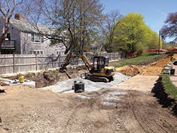
Hyannis Inner Harbor BMP during construction
These volumes above translate to approximately 30% of the WQv. As the WQv is equivalent to the 1-inch storm event, the design storm volume at each location is approximately equal to the 0.3-inch storm event.
Design and Construction
Construction at both sites entailed installation of a new deep-sump manhole within the existing stormwater drain line to provide pretreatment by allowing sediment particles to settle out, helping to keep the BMP free of sediment and making maintenance easier. This structure was also equipped with a diversion wall, effectively making it serve as an inlet control structure. In its finished configuration, small storms up to 0.3 inch, as well as the beginning part of larger storms, are designed to encounter the diversion wall where stormwater is directed into the BMP via a new pipe. This structure is also designed so that larger storms exceeding the design capacity of the BMP will flow over the diversion wall and continue through the existing drainage pipes, similar to existing conditions.
Upon leaving the inlet structure, stormwater directed into the BMP will pass through a dedicated sampling manhole, which will be equipped with monitoring equipment at a later date, before flowing into the aerobic portion of the BMP. Here, it is exposed to aerobic bacteria for aerobic oxidation and nitrogen conversion. To adequately store the stormwater volume equivalent to a 0.3-inch storm, stormwater is allowed to pond up to a depth of approximately 1.6 feet in Barnstable and 2.4 feet in Chatham.
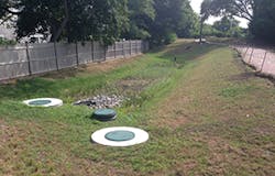
Completed Hyannis Inner Harbor BMP
The bulk of the surface aerobic portion is lined to maximize the flow path through the internal storage reservoir. A small portion is left unlined as part of an infiltration zone to connect the aerobic zone to the anaerobic zone. This area, comprising highly permeable sand and gravel supplemented with organic material, allows stormwater to quickly percolate into the underlying anaerobic gravel cell.
Additionally, this area was seeded with an initial carbon source to assist with the denitrification process and speed anaerobic bacteria development to create anaerobic conditions in the internal storage reservoir. A perforated riser pipe was also incorporated into both BMPs to provide additional capacity should the infiltration zone become plugged. Once in the anaerobic cell, bacteria provide denitrification as previously outlined.
Stormwater migrates through the internal storage reservoir to an outlet control structure equipped with 1-inch-diameter orifices, designed to slowly release stormwater over a 24-hour to 48-hour period to maximize flow path through the anaerobic zone for optimal denitrification. Outlet orifices are located at the top of the internal storage reservoir, thereby keeping this zone fully saturated at all times and in anaerobic conditions. Once released from the BMP, stormwater will flow through a second dedicated sampling manhole, to be equipped with monitoring equipment at a later date. Overflow from the Barnstable BMP flows back into the existing drainage line where it flows into Hyannis Inner Harbor, similar to existing conditions, while the Chatham BMP outlets stormwater into the wetland complex at the rear of the site. Both BMPs are also equipped with overflow/bypass manholes that will collect and safely bypass stormwater that exceeds the capacity of the BMP.
Additional design elements included a perimeter drain around both BMPs to prevent mixing of groundwater with stormwater. A maintenance road was also constructed at the Chatham location to provide maintenance access. Maintenance requirements are anticipated to be relatively minor. Communities will need to periodically monitor the deep-sump inlet control structure and clean out sediment if needed. Periodic landscaping will also be required to trim excess vegetation growth. Each community will be provided with an operation and maintenance plan to document future required action.
Both BMPs are designed as a plug-flow system, such that stormwater will remain within the internal storage reservoir until the next storm occurs. This future storm will exert a hydraulic head on stormwater from the first storm within the subsurface gravel wetland cell, and thus push it out of the overflow structure to make room for the new storm.
Landscaping
Landscaping was an important feature at both BMP sites, both to provide nutrient uptake through the root systems and for aesthetic reasons. Because of the Barnstable BMP’s location within the park area, the BMP had to incorporate plantings to suitably accentuate the beauty of the bioretention area. For this reason, the Cape Cod Commission designed a planting plan consisting of several hundred planting plugs. Native species were chosen to be particularly drought, flood, and salt tolerant. The Chatham BMP was planted with grass seed within the basin itself; however, the side slopes were planted with native shrubs to provide slope stabilization, wildlife habitat, and project beautification.
Future Monitoring
As a final project component, both BMPs will be equipped with sampling equipment at a later date, designed to analyze stormwater flows and water-quality parameters of stormwater influent, effluent, and stormwater bypasses of each system. Federal and state environmental agencies will monitor both sites to evaluate water-quality parameter removal efficiencies realized by installing these BMPs. Sampling is expected to commence approximately one year after systems are brought online to allow bacteria to “seed” within each BMP, and will likely continue for at least two years.
STAKEHOLDERS COOPERATION
A critical goal of this project is to promote public awareness and build support among community members for green infrastructure. Numerous stakeholders were engaged throughout the project, beginning before project startup, through the design and permitting process, construction, and finally after completion as part of ongoing public outreach efforts. Stakeholders included neighborhood residents interested in the project; local municipalities of Barnstable and Chatham, including municipal departments such as the Department of Public Works Conservation Commission and Parks and Recreation; regional organizations including the Cape Cod Commission and the Association for the Preservation of Cape Cod; state agencies including the Massachusetts Department of Environmental Protection; and finally federal agencies such as EPA. Each group had differing goals and concerns, including project budget, schedule, and construction techniques; ease of maintenance; landscaping; and project beautification. Broad stakeholder goals had to be balanced throughout project design and construction process.
NITROGEN CYCLE
The nitrogen cycle is the process by which nitrogen is converted between various forms through several biological and physical processes, including fixation, assimilation, nitrification, and denitrification. Nitrogen fixation is a process in which organic nitrogen is converted into ammonium (NH4+). Most fixation is done by bacteria that combine organic nitrogen with hydrogen to produce ammonia products.
Assimilation is the process by which plants take nitrogen from the soil by absorption through their root systems. Nitrification is an aerobic process by which ammonia becomes oxidized, thus converting ammonium (NH4+) into nitrite (NO2-) and later nitrate (NO3-). This process is performed primarily by organisms living in surficial soil layers where oxygen is present.
Denitrification is an anaerobic biochemical process resulting in the reduction of nitrate (NO3-) and nitrite (NO2-) by microorganisms. This process produces the gaseous products nitric oxide (NO), nitrous oxide (N2O), and ultimately nitrogen gas (N2) for release into the atmosphere, completing the nitrogen cycle. Denitrification occurs readily in anaerobic environments with oxygen concentrations less than 10% and an available organic carbon source to act as an electron donor.
SCHEDULING
Both Cape Cod communities expressed concern that construction could impact the busy summer tourist season. This was a particular concern in Barnstable, as the proposed BMP would be constructed in a small park in the downtown area that is frequently used as a cut-through for customers using the ferries to Nantucket and Martha’s Vineyard.
For the Chatham project, the site was located away from busy areas of town, with traffic generally limited to local residents and a small amount of boat ramp traffic. Additionally, most construction could take place off the road without disrupting traffic flow. After coordinating with both communities, it was decided that the Barnstable project would be constructed in the spring, and could therefore be completed during the tourist off-season so that construction would not disrupt foot traffic through the park during the busy summer months. In Chatham, work taking place off the street could be performed throughout the summer; however, road work would take place during the fall months after the busy tourist season comes to an end and boat ramp traffic slows.
