On some erosion control projects, “soft-armor” methods like willow stakes and coir logs aren’t strong enough on their own to control the forces of water. An example of such a project might be one that is undertaken to stabilize a channel.
The velocity of water when it flows within the relatively narrow confines of a creek or other channel increases its ability to cause damage to adjacent land. That is especially so when high-intensity rain events occur.
That’s when an erosion control specialist may need to call in the cavalry: a revetment system of hard armor. And in certain projects, using a little hard armor allows soft armor to control erosion on the rest of the site.
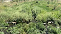
Johnson Creek flows for 13 miles through Tarrant County and Dallas County, TX, including the cities of Arlington and Grand Prairie. It is a tributary of the Trinity River.
In 2016, the City of Arlington undertook a major construction project involving Johnson Creek. The existing bridge on Abram Street over the creek, adjacent to Meadowbrook Park and not far from the Dallas Cowboys stadium, was replaced.
Wier & Associates Inc. of Arlington did the engineering design work for this project. Philip Graham, senior associate with Wier & Associates, served as project manager for the bridge replacement project.
Graham describes Abram Street as “a minor thoroughfare. It was overtopped in as little as a five-year storm event. The City of Arlington wanted to get this roadway elevated so it didn’t have to be closed in even minor storm events.”
He says, “From the top of the bank to the bottom of the creek is about eight feet or so in its natural state. There is minimal flow in the creek the majority of the time. In summer, the creek is four to six inches deep at most.”
Graham explains that rain events change the situation quickly. “We have short-duration, high-intensity storms, heavy downpours that create floods. In a short time, the creek goes from six inches to three, four, five feet deep. 24 hours later, most of stormwater is gone.”
The new bridge was built 9 feet higher than the old bridge, and an old drainage culvert was replaced with a wider open channel. These changes were made to alleviate roadway flooding during storms.
The additional height of the new bridge will significantly reduce flooding and closure of the road. The base of the bridge, the section most vulnerable to flooding and therefore scouring, needed some type of stabilization to counter the forces of water over time.
“The bridge design itself was fairly straightforward,” says Graham. “We limited the depth of the beams to assist with water surface. We used box beams to create a low profile and keep the underdeck as minimal as possible.”
He adds, “The City has encouraged a more aesthetically pleasing redevelopment along this corridor. There is a hike-and-bike trail underneath, above a vertical retaining wall.”
Graham explains, “On the south side of Abram Street is Meadowbrook Park, one of the City’s highly used parks. Immediately adjacent to the creek [within the boundary of the park] is a horseshoe pit. We used gabions to stabilize the wall here.”
The gabions were 3- by 3- by 3-foot basket cubes, buried three to four levels deep. The project included additional work upstream of the bridge. This was done to stabilize the creek’s banks and limit erosion.
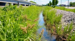
Graham specified EnviroFlex articulating concrete block revetment for scour protection around the bridge’s footprint. Enviroflex is made by Soil Retention Systems Inc., of Carlsbad, CA.
This project was Graham’s first experience with EnviroFlex. He did some research on various types of products and determined that EnviroFlex would be the best one for the site.
“We had a lot of 404-jurisdictional items, getting the permits with the Army Corps of Engineers (ACE). One key item was that the Corps did not want plain concrete riprap. They wanted something that promoted a more natural look, with more vegetation.”

The Corps first recommended a rubber turf reinforcement mat with plastic ties. Graham wasn’t convinced that this type of product would remain intact after having cleaning equipment rolled over it multiple times.
“Silt had built up during construction and needed to be cleaned out,” he notes. “The ability to get equipment down and do maintenance of the creek when needed was a big driving factor for the client [the City of Arlington].”
With the need to satisfy requirements of both the ACE and the City in mind, “I went looking for a product that had the potential to stand up to having equipment on it for cleaning. I researched and presented EnviroFlex to the Corps of Engineers, and they agreed.
“Another important selling point was that we have used cable-connected blocks before, but we had issues with them. They were very susceptible to uplift if the water can get underneath the blocks,” he says. “The blocks sit on a geotextile layer, but water can lift it and pull them out of place. That’s another reason I spent a lot of time looking for an alternative for this project. It needed blocks that would hold in place under high-velocity conditions, plus workers can get into the site for maintenance.”

He explains, “EnviroFlex interlocks on the upstream side. You can cable-tie it to a retaining wall, so that’s how the upper blocks are tied, but the rest are held in place by interlocking [with each other]. There is a concrete toe on the upstream and downstream sides.”
He adds, “The interlocking blocks are fine for scraping across with a skid steer. A worker couldn’t yank a block out during maintenance. The vegetation growth for a more natural look was a selling point for the Corps of Engineers.”
The EnviroFlex “was a guinea pig.” And since it met expectations, “now we have it included in two more projects for the City of Arlington,” says Graham.
EnviroFlex was designed for use in areas with high-velocity water flows that are subject to scour. The system’s concrete blocks interlock vertically with adjoining blocks and do not require the use of cables or chains. These overlapping connections prevent blocks from protruding out of place. Once installed, the EnviroFlex blocks stay put.

After the project was
completed
EnviroFlex is manufactured from fiber-reinforced concrete for added tensile strength. Openings in the block allow for infiltration and groundwater recharge to help mitigate flooding and stormwater pollution. These openings also allow vegetation to establish itself faster with space to grow and exposure to light. The established vegetation promotes biofiltration and results in a green, natural appearance.
When Graham started design work on the project in 2006, he discovered that the original flooding models were “probably 30, 35, even 40, years old. Arlington has grown exponentially over the last 40 years from a small bedroom community to a population of about 450,000.”
He says subsequent studies on the watershed indicate that water levels and flooding rates from 10-, 25-, and 100-year storm events have increased. “As a result, there was increased runoff and no detention involved.”
The project began when the old bridge was closed to traffic in May 2016. After it was demolished, construction started on the new bridge. It was finished and opened to traffic in early February 2017.
EnviroFlex offers a cost-effective and environmentally friendly alternative to riprap, gabion mattresses, solid concrete, asphalt linings, and other hard-armor systems. Because it is thinner than many other materials and systems, its installation requires less excavation, trucking, and handling. Both labor costs and work time are reduced.
Delivered on pallets, EnviroFlex can be placed with small tracked equipment in locations that don’t have enough space for cranes. This also causes less disruption on environmentally sensitive sites.
A specialized grappling tool allows an excavator to install four pieces (13 square feet) of EnviroFlex at a time. This method saves time and labor costs and also helps eliminate gaps between blocks that could impair performance.
Protecting the footprint of the Abram Street bridge required 31,000 square feet of 4-inch EnviroFlex. Between February and March 2017, 26 truckloads with 410 pallets of EnviroFlex block, One-Mat Pins, and other materials were delivered to the project site.
The EnviroFlex was installed on top of a 4- to 6-inch gravel base. The base provides some structural support. It also helps with infiltration of stormwater into the silty, sandy soil and thereby lessens water depth during storms. Beneath the gravel is a geotextile layer.
No seeding was done into the openings of the EnviroFlex blocks. Revegetation would happen naturally as seeds were carried in with stormwater runoff flowing through the site.
“We have a long growing season here,” notes Graham.
The Enviroflex “was actually installed pretty quickly,” he recalls. “We had to get it done before a storm. We had had rain prior to installation, so the ground was very muddy and conditions were wet.”
An existing railroad bridge downstream of the new bridge causes water to back up in the creek. A 10-year storm event results in 24 feet of water over the EnviroFlex installation, but it has remained in place.
“The City has been very happy with it,” notes Graham. “I believe that for certain types of projects, where a natural look as well as a durable product that maintenance can be performed on, this fits the bill.”
Klutz Construction Inc., of Kennedale, TX, a general engineering contractor, was the subcontractor that installed the EnviroFlex and other channel improvements. Tiseo Paving Company of Mesquite, TX, was the prime contractor for the project.
Soil Retention sold the Enviroflex through its distributor, GeoSolutions Inc. This supplier of erosion control and soil stabilization products is located in Grand Prairie, very close to the project site.
The bridge replacement over Johnson Creek was part of a multiyear project to rebuild Abram Street east to Arlington’s border with the suburb of Grand Prairie. The purpose of these multiyear upgrades on this heavily traveled road was to improve transportation within the region.

The new bridge over Johnson Creek
Indian Lake State Park
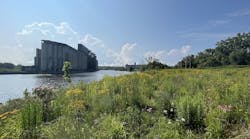
Indian Lake State Park is located in Logan County, west central Ohio, about 20 miles southeast of Lima. Within its boundaries is a 5,100-acre manmade lake.
The lake was constructed in 1851 as part of the Miami and Erie Canal system. Canals were then an important part of commercial transportation, and, to a lesser degree, passenger travel, in the Great Lakes region.
But by the time of the lake’s completion in 1860, use of canal systems was declining. The much faster transit of people and goods by railroad brought about their demise.
In 1898, the Ohio General Assembly dedicated Indian Lake as a recreation area for the public. It eventually became part of Ohio’s system of state parks. With its two sand beaches, islands to explore, and Ohio’s second-largest inland lake, the state park has recreational opportunities focused around fishing, boating, and other water-related activities.
An update to Ohio’s probable maximum precipitation parameters was published in 2013. With this update, the parameters used for modeling water-control structures were revised and new probable maximum flood levels were established. Using these parameters and results, the spillway at Indian Lake was designed to meet the current standards.
Stantec Consulting Services of Columbus, OH, was responsible for the engineering design and construction administration work on an $8 million project at Indian Lake for the Ohio Department of Natural Resources (ODNR). Construction on the project was done by C.J. Mahan Construction, also of Columbus.
“The main focus of the project was to remove the existing ogee-style spillway, which was in a deteriorated condition, and replace it with a new labyrinth-style spillway,” explains Rob Kirkbride, principal with Stantec. “The project was basically replacing the old spillway and improving the flowability within the spillway.”
He adds, “State Route 366 is immediately downstream of the spillway, and water flowing over the spillway has the potential to erode portions of the roadway.”
Originally, dumped rock lined the downstream spillway channel. It had become uneven and less functional over the years.
“We thought articulated concrete blocks would do a better job protecting the roadway from erosion during significant flow over the spillway,” says Kirkbride.
The old ogee weir was replaced with a new labyrinth spillway slightly over 700 feet in length. It is the second-longest labyrinth spillway of its kind in the US. The sharp zigzag angles of the labyrinth resulted in a striking design that looks like a piece of modern sculpture.
However, this labyrinth is highly functional as well as aesthetically pleasing. It can pass 8% more water than the old spillway could without increasing the head.
The two-stage crest labyrinth spillway not only met state requirements for service spillway discharge to match existing spillway discharge up to the 100-year flood event, but actually exceeded them by adding more capacity for events over the 100-year flood event.
“The middle section of the spillway is one and a half feet lower than are its two sides. This middle section, about 180 feet long, has similar capacity to the old spillway, a 700-foot-long ogee weir. It [alone] can handle runoff up to a 100-year storm event,” explains Kirkbride.
“If a storm event larger than a 100-year storm happens, the two sides of the spillway are activated to allow additional flow over the spillway, which is a significant improvement on the old one.”
Below the spillway’s center section (which receives the primary overflow) is a concrete stilling basin that contains a foot of water. Its purpose is to dissipate the energy of the water flowing over and so minimize erosion or scouring. Farther downstream of this stilling basin is a layer of large rock, type A aggregate.
Kirkbride says that labyrinth spillways are not as common yet as the older ogee spillways. But because they are more efficient than ogee spillways, “You’re probably going to see more of them.”
Work on the new spillway project started in February 2017 and completed in July 2018. It had to be done in two phases.
“We had to keep half of the spillway open and available to pass flow during construction. So the west side was replaced first, then we did the east side,” says Kirkbride.
“As with most spillway construction projects, the main challenge of the project was trying to control water. Unfortunately, we had multiple large storm events during construction, and the contractor had to delay work to allow water to recede from the work area. Thankfully, we had an experienced contractor who knew how to handle this situation.”
The cold temperatures during the winter of 2018 were sometimes a problem when concrete had to be poured. Some special techniques had to be employed to keep the concrete warm enough not to freeze.
In eight days, the contractor’s crew installed 22,621 square feet of ArmorFlex Class 45 articulated concrete block (ACB) mattresses. ArmorFlex is a product from Contech Engineered Solutions of West Chester, OH.
The ArmorFlex ACBs come in four types: closed-cell (as used on this project), tapered open-cell, open-cell, and Block and a Half. The open-cell blocks are suitable for projects that require revegetation. The closed-cell blocks can support more weight and are the best choice for sites that must bear vehicular traffic or heavy equipment or materials.
ArmorFlex ACBs are suitable for many applications where hard-armor revetment is required, including scour and slope protection, weirs, spillways, and shoreline restoration.
“The installation was fairly straightforward, but care has to be taken to install the blocks,” says Kirkbride. The contractor’s crew used a large crane with “a big beam, a spreader bar to keep the blocks spread out as they were placed on the prepared ground surface.”
Under the ACBs is a layer of woven geotextile fabric. It was used to minimize erosion under the blocks. Beneath the geotextile layer is a layer of aggregate, a 304 roadway-type stone.
“That leaves a flat surface after compaction, so you can place the ACBs at the designed elevations,” says Kirkbride.
The ArmorFlex helps control erosion in two ways. It allows for unencumbered flow downstream of the spillway. It also provides erosion protection for the State Route 336 roadway embankments.
The ArmorFlex ACBs line the downstream spillway channel in two parallel swaths, a total width of about 35 feet. The blocks are connected to each other with nylon cables. The two tracks are not tied together or structurally connected, but grout was poured in the gaps at their inner adjoining edges.
Kirkbride had used ArmorFlex in previous projects, but none were as large as the spillway project at Indian Lake. He says that it was a good choice, cost-wise. To get the same amount of function from rock, he would have had to place the large rock to a depth of at least 3 feet, compared to just 7 inches—the height of the concrete blocks. Excavation would have required much more time and therefore more labor cost.
No seeding was needed because vegetation—grasses tolerant of wet conditions—would naturally be brought to the spillway through the flow of stormwater runoff and the sediment it carried. The openings between the concrete blocks would allow the vegetation to grow.
“One of the things we like about ACBs is that you can manage vegetation much easier than when large rock is used. You can drive a mower right on top of the ACBs without damaging them. I believe the ODNR will like this as well,” says Kirkbride.
He has been back to check on the new spillway, and he reports, “It looks like it’s working really well. Flow over the spillway is performing as designed, and vegetation has filled in within some of the blocks, but with or without vegetation is fine.”
Wildlife did not pose any problems during construction. The project did attract a lot of attention from the public because of its proximity to a main road in the state park.
“Someone was there nearly every day, watching and taking pictures,” he recalls.
“They were very interested. They stopped and parked their cars and wanted to know what the heck we were up to. The public was very supportive of the project, and we enjoyed talking with them when they had questions.”
Boaters on the lake also floated by and noticed the construction. Sometimes they stopped for a close-up view of the work site.

Hunter Avenue
Staten Island, NY, is in the midst of a major program to address stormwater and flooding issues. Improving drainage on the island involves constructing and enhancing many wetlands in a total area of 16,000 acres to provide extended detention of stormwater.
“What Mother Nature created years ago is now being enhanced,” says Dahlia Thompson, senior associate with the New York City engineering firm Hazen & Sawyer.
Thompson says that about 130 small BMP projects, mixtures of green and gray infrastructure, have been designed for Staten Island. Buildout will last until 2030. 60 mini-projects have been constructed so far.
One of these is the Hunter Avenue Infrastructure Upgrade, located in the Midland Beach area.
“The downstream area of this project is less than 2,000 feet from the ocean,” notes Thompson. “The houses here are beach bungalows built in the 1950s as summer homes. [Over the years] more full-time residents moved there, especially since the Verrazano Bridge, which connects Staten Island to the city, was built.”

Detail of the new labyrinth spillway
She says, “This area suffered a lot during Hurricane Sandy [in 2012]. It took a long time for the water to drain down, because the area is flat. At high tide, the water is at the same elevation as the houses. The seawalls are there, but easily breached, and the road is overtopped. The residents were very much in favor of the project.”
Part of the work on the Hunter Avenue project and others nearby was removing the invasive phragmite plants. These plants thrive in the brackish water.
When it dries out, this reed-like plant is very flammable. Lightning strikes or a casually tossed cigarette can set it on fire, causing problems for residents.
“We restored a more diverse wetland plant palette,” explains Thompson.
The small project along Hunter Avenue consisted of five forebays and three microponds.
The wetlands there are 5 to 6 feet deep to make sediment capture easier.
To keep the outer edges of these stormwater wetland BMPs stable, 650 square yards of Reno mattresses were installed along three sides of each. These mattresses measure 12 feet by 6 feet by 9 inches. The mattresses were made by Maccaferri Inc. of Rockville, MD. Maccaferri’s Reno mattresses have been used in several of the NYC Department of Design and Construction projects on Staten Island.
“The Reno mattresses make a hard edge, so maintenance is safer for the Vactor truck or Bobcat driver,” says Thompson.
The challenge of this project was “staging things so we still had a flow while maintaining the work area [dry enough for the crew],” she adds.
The bulk of construction and installation was done during the fall and winter so no plants were growing actively. Work on the overall project started in 2015. The Reno mattresses were installed at the end of 2017. The project’s main contractor was J.R. Cruz Corp. of Matawan, NJ.
Problems with wildlife would not be expected in an urban beachfront community. However, some geese got over the exclusion fence to eat the new plants. Keeping this from happening again required some extra work.
Thompson says of the Hunter Avenue project, “It’s been a year and a half, and it’s doing well. The wetlands look good. The flow is still going well.”