It’s a team effort in the city of Rockford, Illinois, where residents will not give up on a neighborhood devastated by floods. The overall goal – to reduce the flood footprint and to have people enjoy rather than avoid Keith Creek – is the same for city officials, neighborhood groups and residents.
Experiencing Keith Creek
Although the most notable floods in Rockford were in 2007 and 2008, the Keith Creek neighborhood has regularly flooded since the 1920s. The area was settled and developed by Swedish immigrants and sits southeast of downtown, abutting small storefront districts and aging industrial properties. Like many rust belt cities, the neighborhood has undergone changes. Thriving industries are no more, but they have left a diverse working-class community.
Keith Creek’s urbanized watershed moves water quickly to the creek when it rains. In a matter of hours, the creek can rise 8 feet, inundating every property in its wake. Fast waters can dislodge debris and even vehicles. The creek was channelized, and the neighborhood was developed long before floodplain and detention regulations were in place, making the area vulnerable to flooding. More than 300 structures lie within the 100-year floodplain.
The area most susceptible to flash flooding is a mile upstream where the watershed drains and discharges into the Rock River. As storm water transitions from relatively steep terrain to a flatter, slower section of the creek waters quickly topple the banks and spill into the 130-acre depression around the creek. As a result, the Keith Creek watershed ranks highest for total flood insurance damage claims in the city.
Finding Solutions
Since major flooding in 2006 and 2007, the city’s response has been multifaceted. Officials secured Federal Emergency Management Agency (FEMA) Hazard Mitigation grants to buy and demolish approximately 130 of the most flood-prone and damaged homes, dramatically reducing flood risk. The Illinois State Water Survey in 2016 evaluated flood risk and potential future damages across all watersheds in Rockford. Though Keith Creek still has a large risk, it no longer has the highest predicted damages because of the successful buy-out program.
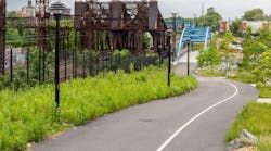
However, what was a typical neighborhood block is now vacant parcels along the concrete-lined creek. They will stay vacant until the city moves forward with a plan for the area.
Like most communities, there are more infrastructure projects than money to pay for them. Brad Holcomb, the city’s stormwater manager, spends his days handling permits, ensuring programs are in place, processing drainage complaints and assessing and inspecting properties while working with homeowners. He said Keith Creek is the first place his team checks after significant rainfall.
Holcomb said his goal is to reduce the city’s flood print and to work toward that as funds allow. His team has widened channels, removed seven pinch point bridges, upgraded the Alpine Dam, stabilized banks and removed sediment. They clean the creek annually but there is still work to do. He said he hopes this year to add an emergency spillway. Small projects have been more cost-effective solutions, he said.
The Keith Creek Neighborhood Association was formed soon after the 2007 and 2008 floods to guide the community through the changes and provide a voice to residents as decisions were made. Neighborhood groups and residents with a rich history and fond memories of Keith Creek hope to resurrect it.
Since funding was a major hurdle, local groups began investigating options to fund creek improvements. Bob Campbell, executive director of Zion Development Corp., a faith-based community organization, got help through the AmeriCorps VISTA program to develop a plan and submit grant applications. It secured an EPA 319 water quality planning grant and an Illinois Department of Transportation Corridor Study Planning Grant. The water quality grant will provide an avenue to build green infrastructure that improves the health of the creek while reducing flooding. The Corridor Study will provide greenway open space plans that can be funded in the future. Together, the grants set up funding for projects along the creek, which can be used to mitigate flooding as well.
This is important to Campbell because though his home is high enough to avoid damage, he drives through floodwaters after heavy rain to get there. He sees the ramifications flooding has on his neighborhood. After the city razed homes and removed seven bridges along the creek to help solve water woes, the neighborhood was drastically changed. Removing bridges left residents with fewer transportation options, and relocating residents cut off some of the social fabric that had been in place for decades.
Although substantial changes might be years, or even decades away, Campbell hopes in the short term, the city can address water quality, flooding, vacant land, lack of accessibility and the inability to use the creek as an amenity. He dreams of seeing a greenway extend to the northeastern part of the city, passing through parks, golf courses and neighborhoods to provide connection for residents and visitors.
Local architect, historic preservationist and community activist Gary Anderson has a soft spot for the Keith Creek neighborhood. He recalls playing, ice skating and gathering along the bank with sometimes hundreds of children drawn to the neighborhood by Rockford Park District events. Even in the 1960s, the streets filled with water after it rained. He said he sees the bigger picture of what the future could be for the area and looks forward to a time when the creek is once again a community asset.
Anderson and his firm, Studio GWA, are part of the consultant team that is completing the greenway and open space plan for Keith Creek.
Reimagining Keith Creek
With properties razed, the area is a blank slate for the future of the waterway and the neighborhood.
Anderson has researched what makes a community better. After flooding is controlled, all he sees are opportunities. With seven parks along Keith Creek, the neighborhood hopes to find funding to connect them. Anderson wants to create habitats, learning centers and recreational opportunities to not only benefit people but the environment.
Meanwhile, Fehr Graham is completing the engineering study for Rockford to determine which Keith Creek improvements can be completed in conjunction with the grant programs to reduce flooding. This ensures grant-funded projects are not isolated and that all parts work together to create community assets and reduce flood risk. Modeling work has been done using HEC-RAS’s 2D module to better understand how floodwaters route through the terrain and buildings within the neighborhood.
A combination of Google Earth’s 3D Imagery and the modeling outputs is one way to communicate risk with city officials and residents. Depth and water movement can be visualized in a map that shows the detailed risk for each property and building within the floodplain.
Modeling will be a key tool for the city to evaluate the effectiveness of flood mitigation measures. Green infrastructure and open space improvements can be integrated into the model, too, giving the city the full scope of benefits provided by future projects.
For some flood mitigation projects, reducing damages is the bottom line. But for the Keith Creek neighborhood, an integrated approach that maximizes financial, environmental and social outcomes is vital to its long-term success.
About the author:
Jeff Macke, PE, is a project manager for Fehr Graham Engineering & Environmental. Macke can be reached at [email protected].