Longitudinal Peak Stone Toe Protection (LPSTP) is a technique that manages riverbank failures and erosion while creating habitat and minimizing long-term maintenance requirements. The LPSTP is a continuous stone dike, triangular in shape, placed longitudinally at or slightly streamward of the toe of the eroding bank. The LPSTP does not necessarily have to follow the toe; it can be placed to form a “smooth” alignment through the river bend. Enough stone is placed so that in the event of a future riverbed scour during a flood, the sacrificial stone can “roll” into the scour hole and stabilize the riverbank from a large failure, thus protecting infrastructure, homes, and natural resources.
Each ton of stone is estimated to provide 3 feet of scour protection based on experience on large rivers in the United States. For example, about 6.5 tons of well-graded stone was used per linear foot for the Victoria, Texas, project outlined below.
General LPSTP design guidance can be found in the United States Army Corps of Engineers (USACE) Engineering Design of Flood Control Channels.^1 The LPSTP was recommended over placing rock riprap under water for the following reasons:
- It would be very challenging to place a toe rip rap section in the alluvial river bottom in wet conditions.
- It would be difficult for construction equipment to extend that far over the river and carefully place the rock rip rap.
- Rock placement underwater cannot be visually observed to confirm proper placement.
Based on the Victoria project design, the LPSTP can provide up to 15 feet of scour protection per linear foot of river.
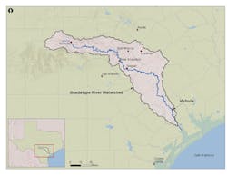
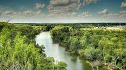
Victoria, Texas, is located about 35 miles from the Gulf of Mexico and approximately 75 miles northeast of Corpus Christi. The city’s primary water intake, which serves a population of 65,000, is situated on the outside meander bend of the Guadalupe River, whose headwaters begin in the Texas Hill Country and flow about 250 miles to San Antonio Bay. The drainage area at Victoria is nearly 5,200 square miles and the river is infamous for flash floods that have caused extensive damage and loss of life. The 10-year flood (10 percent chance event) has a peak discharge rate of 65,700 cubic feet per second (cfs) at a depth of about 28 feet.
Riverbank Failure Cause
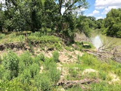
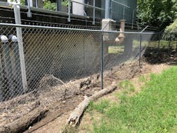
In late August 2017, Hurricane Harvey floodwaters exceeded the bank height by approximately four feet and eroded the riverbank at the water intake through a sapping failure that was geotechnical in nature. The sandy soils became saturated and with a sudden drawdown of river levels, blowouts/slip failures occurred over a length of more than 500 feet along the river’s outside meander bend, generating fallen trees and severe bank loss that edged close to the water intake pump station.
NRCS Involvement/Funding
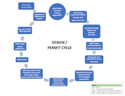
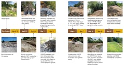
After the riverbank failure, the City of Victoria, led by its City Engineer Ken Gill, PE, contacted the Natural Resources Conservation Service (NRCS), including the State Conservation Engineer John Mueller, to seek guidance, input, and potential funding options. The NRCS visited the site in October 2017 and prepared several potential bank stabilization solutions to estimate the necessary repairs. Alternatives contemplated in the December 2017 Technical Memorandum included stone toe protection, gabions, and mechanically stabilized earth. After consideration of options and funding needs, the city initiated an engineering procurement process and entered into a contract with consulting engineering firm Doucet and Associates Inc. (Doucet) to prepare further refined conceptual designs and a construction cost estimate. The city applied to pursue NRCS funding under the Emergency Watershed Protection (EWP) program in September 2018 and the grant award of $1.7M was approved by the city and NRCS in March 2019. (See Fig. 1 for an overview of the project process.)
Key Design and Permitting Items
Project Design/Management – In April 2019, the city authorized Doucet to prepare the construction plans and obtain all necessary permits. The Doucet team included Holt Engineering Inc. (geotechnical), Balcones Geotechnical, Cox McLean Inc. (environmental and cultural resources), and River Research and Design Inc. Doucet performed all field surveying and engineering design services and managed the project from beginning to construction completion. The city staff provided real estate, construction monitoring, and floodplain assessment support and created an atmosphere of teamwork that continued throughout the project.
Field Survey – The survey identified trees, defined topography, confirmed the wetland extent and mapped the riverbed below the water surface to the middle of the river to locate the water intake structure and define riverbed elevations to establish design parameters to work with existing conditions and protect the slope.
Geotechnical and Slope Stability Analysis – Due to the sapping/slope failure, soil borings were obtained along the river to define soil and subgrade conditions. The analysis performed by Holt Engineering and Balcones Geotechnical evaluated three different constructed slope conditions, ranging from 3-feet horizontal to 1-foot vertical to 5-feet horizontal to 1-foot vertical. The existing bank slopes ranged from near vertical at several locations to 2-feet horizontal to 1-foot vertical. The target factor of safety was recommended as 1.5 and the 4:1 slope achieved a 1.51 factor of safety. Thus, the final slope above the LPSTP was established as 4:1 to minimize the extent of grading, fit the improvements between the river and water pump station, and avoid future slope failures at the intake.
LPSTP Design – Doucet contracted with Dave Derrick, potamologist from River Research and Design, to support and guide the LPSTP design approach. Mr. Derrick has nearly 40 years of experience in designing and constructing creek and river stabilization projects through his work at the United States Army Corps of Engineers, Waterways Experiment Station, Vicksburg, Mississippi, and consulting with entities throughout the United States. About 15 years earlier, Mr. Derrick led the design of a pipeline stabilization project on the Guadalupe River not far from this site and has a solid understanding of the river soils, geology, and hydrology.
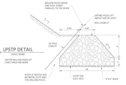
A hydrologic analysis using the USGS Gage Station at Victoria was conducted to establish LPSTP design height and working relationship with the ever-changing flow regime. During the hot Texas summers, river flows can be a trickle, so it was necessary to define water levels to ensure that the willow and sycamore poles placed behind the LPSTP had access to water to sustain growth and survival. These woody plants are key to LPSTP performance in higher flow events by “roughening” the bank surface to slow river velocity, dissipate energy, and minimize scour behind the LPSTP. To establish the design parameters, the median flow was found to be about 900 cfs, which generates a water surface elevation of about 41.3 feet mean sea level (msl) per the Guadalupe River HECRAS model. Thus, the willow and sycamore poles were designed to be a length of 10 feet, such that the tops of the poles would be at elevation 51.0 to extend two feet above ground and have a bottom elevation of about 41.0 msl (see Fig. 2).
At the same time, the LPSTP needed to be of sufficient height to manage frequent flows without overtopping. Based on input from Mr. Derrick, river levels should not exceed the top of the LPSTP more than 5 percent of the year. Based on the USGS gage in Victoria, a peak discharge of about 4,000 cfs is exceeded less than 5 percent of the time. The peak discharge rate of 4,000 cfs was input into the Guadalupe River HECRAS model and it was found that the water surface elevation at the Water Intake site is 48.9. The top of the LPSTP was established at elevation 49.0 to satisfy the criteria.
Floodplain Assessment – The FEMA floodplain models were obtained from the City and the HECRAS cross sections were modified to reflect the proposed project improvements. The HECRAS modeling indicated that there was no change in the Guadalupe River floodplain water surface elevations as a result of the proposed project laying back the bank side slopes and increasing the cross-section area. A floodplain permit application was submitted to the City of Victoria for review and approval.
Cultural resources – A desktop investigation was performed, including a report that was submitted to the Texas Historical Commission (THC) in October 2019. Several potential sites were identified in the region and this portion of the river had experienced significant habitation in the historic area. The THC indicated in its approval that the construction phase was to be monitored by a qualified archeologist so that if cultural resources were uncovered during excavation, the project would pause and the resources would be evaluated. After initial excavation, the soil layers indicated significant disturbance from unknown events. At that point in time, several test pits were excavated to verify the soil conditions. Based upon the in-situ soil testing, the THC no longer required construction monitoring, thus saving about $10,000 and ensuring that the project could proceed without the risk of work stoppage.
Corps of Engineers 404 Permit – From the environmental survey, less than 0.05 acres of wetlands were impacted by the proposed project. After consultation with the Corps of Engineers, the design team applied Nationwide Permit (NWP) 37, Emergency Watershed Protection and Rehabilitation to the project. The LPSTP assisted in the permit application process by providing habitat for aquatic species. A Pre-Construction Notice (PCN) was filed and approved by the Corps of Engineers and no mitigation was required. The PCN included information on cultural resources to assist in the construction monitoring program.
Project Construction
Lester Contracting Inc. (Port Lavaca, Texas) was the project contractor and worked as a proactive team member throughout the process. The equipment operators and team provided insight into unique construction aspects and coordinated with Mr. Derrick and Doucet and Associates in the field to refine procedures, slightly adjust the LPSTP centerline to better fit the river bend, and “connect” the LPSTP to the existing terrain and vegetation at both the upstream and downstream ends. Company owner Ken Lester noted, “The project team was great to work with, [and it was] a very constructible design. The LPSTP approach saved time and money as it is much easier to work above the river level than have to dewater in an active river for subsurface improvements. The project was built ahead of schedule and on-budget with no change orders.”
Dave Derrick summed up the project: “We have been building LPSTPs for almost 30 years, ranging from small streams to the Missouri River. Once the vegetation is established and locked in, it is a very resilient practice and able to withstand major floods.”
Project Summary
The project was determined to be substantially complete on June 10, 2020, and verified by a field review with NRCS, the city, and the design team staff. The total project cost was about $650,000 with the NRCS reimbursing the city for 90 percent of the total construction cost. The NRCS also provided partial reimbursement for design and technical assistance fees.
“The overall process of working with the NRCS in obtaining advice and funding is a compliment to their agency," said Gill. "They were very helpful throughout the entire process. In addition, the engineering team went to great lengths to find alternatives to structural systems such as walls and sheet piling. The constructed project is much better for the environment as the natural system works with the river, provides habitat, and requires little to no maintenance by the city. Nature takes care of the maintenance for us. ”
Tom Hegemier, PE, DWRE, CFM, is a senior project manager at Doucet and Associates, Austin, Texas, and is on the Stormwater Magazine Editorial Advisory Board.
References
1. Engineering and Design: Hydraulic Design of Flood Control Channels, Engineer Manual, U.S. Army Corps of Engineers, Washington, D.C., 1994. See: https://apps.dtic.mil/dtic/tr/fulltext/u2/a402524.pdf (accessed April 12, 2021).
Published in Stormwater magazine, May 2021
